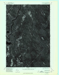
1975 Map of Wytopitlock SE
USGS Topo · Published 1980About this map
Mattawamkeag River defines the western landscape of this mid-1970s orthophotoquad, winding through the dense timberlands of Penobscot County. This specific imagery, captured from an aerial photograph taken in May 1975, offers a precise visual record of the region's managed forests and drainage patterns. The course of Meadow Brook is clearly visible as it cuts through the terrain, punctuated by irregular patches of clearing and regrowth that reveal the local logging footprint of the era. Unlike traditional topographic maps, this orthophoto provides a direct photographic look at the vegetation density and wetland margins surrounding the river system, serving as a vital reference for environmental historians and land-use researchers studying Maine's interior woodlands before modern development or forest management shifts.
Find a feature on this map
2 named features on this map. Tap any name to fly to it.
Don’t see what you’re looking for? This feature index may not catch every label — zoom into the map to look around manually.
Map Details
Editions of this 1975 Wytopitlock SE Map
This is the sole edition of this map. No revisions or reprints were ever made.
Other maps of this area

1931 · Springfield
USGS Topo · 1:48,000

1934 · Springfield
USGS Topo · 1:62,500

1940 · Danforth
USGS Topo · 1:62,500

1941 · Danforth
USGS Topo · 1:62,500

1941 · Scraggly Lake
USGS Topo · 1:62,500

1941 · Wytopitlock
USGS Topo · 1:62,500

1943 · Danforth
USGS Topo · 1:62,500

1943 · Wytopitlock
USGS Topo · 1:62,500

1944 · Scraggly Lake
USGS Topo · 1:62,500

1954 · Millinocket
USGS Topo · 1:250,000