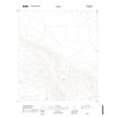
2019 Map of Y E Mesa
USGS Topo · Published 2019About this map
Y E Mesa and the surrounding high desert of Brewster County are defined by a landscape of dramatic elevation changes and seasonal watercourses. This survey by the U.S. Geological Survey documents the eastern reaches of the Santiago Mountains, where the terrain drops sharply toward Javelina Draw and the basin of Maravillas Creek. The isolation of the region is evident in the sparse infrastructure, with only Chalk Draw Rana Rd skirting the western slopes. A critical water source in this arid environment, Y E Spring sits tucked against the mesa's western flank, highlighting the essential relationship between geography and survival in the Trans-Pecos. Local drainage is further defined by Hackberry Creek and Spring Creek to the north, while Red Mtn stands as a prominent sentinel at the southern edge of the quadrangle.
Find a feature on this map
10 named features on this map. Tap any name to fly to it.
Don’t see what you’re looking for? This feature index may not catch every label — zoom into the map to look around manually.
Map Details
Editions of this 2019 Y E Mesa Map
This is the sole edition of this map. No revisions or reprints were ever made.
Other maps of this area

1917 · Santiago Peak
USGS Topo · 1:62,500

1917 · Bone Spring
USGS Topo · 1:62,500

1917 · Hood Spring
USGS Topo · 1:62,500

1918 · Bone Spring
USGS Topo · 1:125,000

1918 · Hood Spring
USGS Topo · 1:62,500

1918 · Santiago Peak
USGS Topo · 1:62,500

1918 · Bone Spring
USGS Topo · 1:62,500

1918 · Nine Point Mesa
USGS Topo · 1:62,500

1920 · Bone Spring
USGS Topo · 1:62,500

1931 · Hood Spring
USGS Topo · 1:62,500