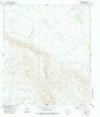
1983 Map of Y E Mesa
USGS Topo · Published 1984About this map
Santiago Mountains rise sharply above the arid expanse of the Santiago Flats in this Brewster County landscape. The terrain is defined by dramatic elevation changes, notably at the titular Y E Mesa, where the land drops off into a complex network of seasonal drainages. Water management in this high desert environment is evident through scattered Tanks and Water Tanks positioned to capture runoff from the limestone peaks.
Find a feature on this map
16 named features on this map. Tap any name to fly to it.
Don’t see what you’re looking for? This feature index may not catch every label — zoom into the map to look around manually.
Map Details
Editions of this 1983 Y E Mesa Map
This is the sole edition of this map. No revisions or reprints were ever made.
Other maps of this area

1917 · Santiago Peak
USGS Topo · 1:62,500

1917 · Bone Spring
USGS Topo · 1:62,500

1917 · Hood Spring
USGS Topo · 1:62,500

1918 · Bone Spring
USGS Topo · 1:125,000

1918 · Hood Spring
USGS Topo · 1:62,500

1918 · Santiago Peak
USGS Topo · 1:62,500

1918 · Bone Spring
USGS Topo · 1:62,500

1918 · Nine Point Mesa
USGS Topo · 1:62,500

1920 · Bone Spring
USGS Topo · 1:62,500

1931 · Hood Spring
USGS Topo · 1:62,500