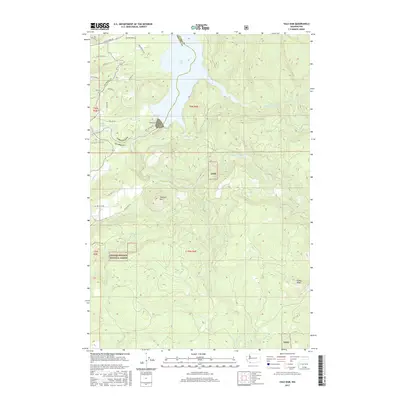
2017 Map of Yale Dam
USGS Topo · Published 2017About this map
Yale Dam stands as the central engineering landmark along the Lewis River, anchoring the significant reservoir of Yale Lake as it straddles the boundary between Cowlitz and Clark counties. This 2017 topographic survey highlights a landscape defined by industrial water management and protected wilderness, with the Gifford-Pinchot National Forest covering the southern and eastern sectors. The terrain is notably vertical, rising from the lake shores toward prominent peaks such as Tumtum Mtn and Green Knob. A network of rural and forest roads, including Yale Village Rd and Saddle Rd, provides access to the dispersed properties and recreational areas surrounding Lake Merwin. Numerous drainages like Canyon Creek and Siouxon Creek carve through the heavily forested uplands, illustrating the complex hydrology of the Pacific Northwest's Cascade foothills.
Find a feature on this map
38 named features on this map. Tap any name to fly to it.
Don’t see what you’re looking for? This feature index may not catch every label — zoom into the map to look around manually.
Map Details
Editions of this 2017 Yale Dam Map
This is the sole edition of this map. No revisions or reprints were ever made.
Other maps of this area

1919 · Mount St Helens
USGS Topo · 1:125,000

1940 · Lookout Mtn
USGS Topo · 1:62,500

1941 · Yacolt
USGS Topo · 1:62,500

1948 · Vancouver
USGS Topo · 1:250,000

1950 · Vancouver
USGS Topo · 1:250,000

1950 · Vancouver
USGS Topo · 1:250,000

1953 · Hoquiam
USGS Topo · 1:250,000

1953 · Lookout Mtn
USGS Topo · 1:62,500

1953 · Cougar
USGS Topo · 1:62,500
1956 · Yacolt
USGS Topo · 1:62,500