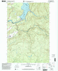
2000 Map of Yale Dam
USGS Topo · Published 2003About this map
Yale Dam sits at the center of this hydro-electric and recreational landscape, anchoring the transition between Yale Lake and Lake Merwin on the Lewis River. The map highlights the infrastructure of the area at the turn of the millennium, including a Saddle Dam, Spillway, and a Gaging Station. Near the settlement of Yale, the presence of a Cem, an Airstrip, and a Mobile Home Park indicates a community shaped by its proximity to these major reservoirs.
Find a feature on this map
31 named features on this map. Tap any name to fly to it.
Don’t see what you’re looking for? This feature index may not catch every label — zoom into the map to look around manually.
Map Details
Editions of this 2000 Yale Dam Map
This is the sole edition of this map. No revisions or reprints were ever made.
Other maps of this area

1919 · Mount St Helens
USGS Topo · 1:125,000

1940 · Lookout Mtn
USGS Topo · 1:62,500

1941 · Yacolt
USGS Topo · 1:62,500

1948 · Vancouver
USGS Topo · 1:250,000

1950 · Vancouver
USGS Topo · 1:250,000

1950 · Vancouver
USGS Topo · 1:250,000

1953 · Hoquiam
USGS Topo · 1:250,000

1953 · Lookout Mtn
USGS Topo · 1:62,500

1953 · Cougar
USGS Topo · 1:62,500
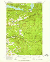
1956 · Yacolt
USGS Topo · 1:62,500