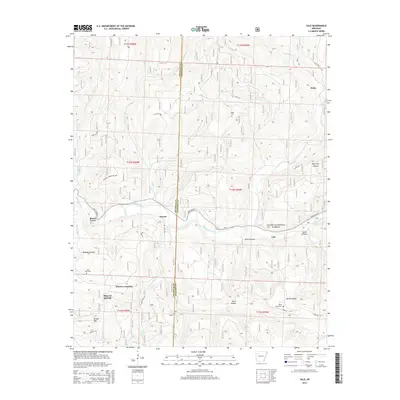
2014 Map of Yale
USGS Topo · Published 2014About this map
The Mulberry River winds through the heart of this landscape, marking the rugged transition between Franklin and Johnson counties. The area is defined by the deep valleys of the Ozark National Forest, where small settlements like Beach Grove and Yale are tucked into the river bends. The terrain is deeply carved by drainage systems including Clear Creek, Indian Creek, and Herrods Creek, which flow southward from the heights of Brushy Mountain. Genealogy and local history researchers can identify several isolated burial sites, including Yager Cemetery and Lone Pine Cemetery, alongside small crossroads and railway points such as Pittston Junction and Peanut. The presence of Mineral Springs and named hollows like Sarah Hollow and Wolf Pen Hollow suggests a pattern of historic homesteads and resource-dependent communities that persisted long after the establishment of the national forest boundaries.
Find a feature on this map
44 named features on this map. Tap any name to fly to it.
Don’t see what you’re looking for? This feature index may not catch every label — zoom into the map to look around manually.
Map Details
Editions of this 2014 Yale Map
This is the sole edition of this map. No revisions or reprints were ever made.
Other maps of this area

1879 · Cravens
USGS Topo · 1:62,500

1887 · Watalula
USGS Topo · 1:62,500

1906 · Batson
USGS Topo · 1:62,500

1939 · Watalula
USGS Topo · 1:62,500

1943 · St. Paul
USGS Topo · 1:62,500

1946 · St. Paul
USGS Topo · 1:62,500

1956 · Russellville
USGS Topo · 1:250,000
1963 · Harmony
USGS Topo · 1:24,000
1963 · Hunt
USGS Topo · 1:24,000

1964 · Russellville
USGS Topo · 1:250,000