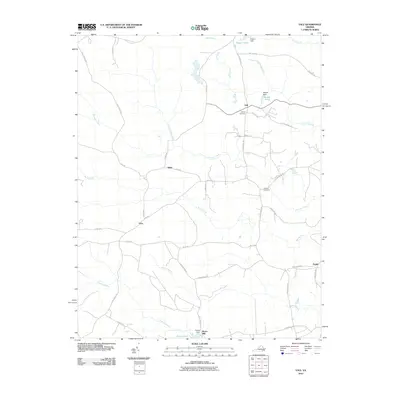
2010 Map of Yale
USGS Topo · Published 2010About this map
Rivers Mill stands near the southern edge of this Southampton County landscape, where the waters of Hornet Swamp and Poplar Swamp converge toward Rivers Pond. The area is defined by a traditional rural settlement pattern, with small communities like Yale, Hilda, and Gray connected by a network of local routes such as Courthouse Rd and Butts Rd. This 2010 survey illustrates the persistence of these small crossroads and the importance of local water management, evidenced by several small reservoirs including Magee Pond and Rogers Pond. Genealogy researchers will find several well-defined family and community landmarks, such as Calvary Cemetery and Antioch Cemetery, which serve as anchors for the surrounding agricultural tracts. The terrain is characterized by the slow-moving drainage of Raccoon Creek and Spring Creek, which wind through the low-lying eastern Virginia plains toward the Nottoway River basin.
Find a feature on this map
44 named features on this map. Tap any name to fly to it.
Don’t see what you’re looking for? This feature index may not catch every label — zoom into the map to look around manually.
Map Details
Editions of this 2010 Yale Map
This is the sole edition of this map. No revisions or reprints were ever made.
Other maps of this area

1919 · Jarratt
USGS Topo · 1:62,500

1919 · Homeville
USGS Topo · 1:48,000

1919 · Boykins
USGS Topo · 1:48,000

1919 · Arringdale
USGS Topo · 1:48,000

1920 · Homeville
USGS Topo · 1:62,500

1920 · Boykins
USGS Topo · 1:62,500

1920 · Arringdale
USGS Topo · 1:62,500

1942 · Arringdale
USGS Topo · 1:62,500

1943 · Sebrell
USGS Topo · 1:31,680

1943 · Littleton
USGS Topo · 1:31,680