
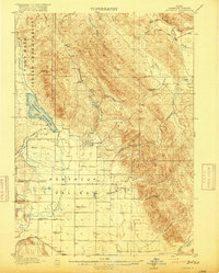
1955 Map of Yandell Springs
USGS Topo · Published 1957About this map
The Fort Hall Indian Reservation boundary defines much of this mid-century landscape, where the high desert terrain of Southeast Idaho meets industrial activity and pioneer history. The map marks the Fort Hall No 2 Historic Site near the Lincoln Creek Valley, providing a specific point of reference for the region's early settlement and travel routes. By the mid-1950s, resource extraction is a visible driver of local development, evidenced by the Westvaco Mine and its accompanying Westvaco Siding along the Union Pacific line.
Find a feature on this map
54 named features on this map. Tap any name to fly to it.
Don’t see what you’re looking for? This feature index may not catch every label — zoom into the map to look around manually.
Map Details
Editions of this 1955 Yandell Springs Map
This is the sole edition of this map. No revisions or reprints were ever made.
Other maps of this area
1917 · Portneuf
USGS Topo · 1:62,500
1918 · Paradise Valley
USGS Topo · 1:62,500

1924 · Ammon
USGS Topo · 1:62,500

1937 · Pocatello
USGS Topo · 1:48,000

1940 · Blackfoot
USGS Topo · 1:62,500

1943 · Blackfoot
USGS Topo · 1:62,500

1944 · Pocatello
USGS Topo · 1:62,500

1950 · Goshen
USGS Topo · 1:24,000
1951 · Higham Peak
USGS Topo · 1:24,000

1952 · Goshen
USGS Topo · 1:24,000