
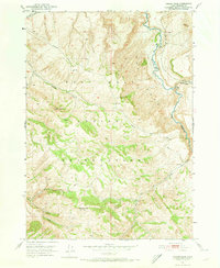
1951 Map of Higham Peak
USGS Topo · Published 1952About this map
The Fort Hall Indian Reservation landscape is defined by its rugged elevations and a critical network of natural and engineered water sources. Surveyed in the early 1950s, the terrain rises to prominent heights at Higham Peak and Garden Peak, serving as a backdrop for the winding course of the Blackfoot River. The presence of the Little Indian Ditch in the northern sector highlights early water management efforts within the reservation, supporting the local geography alongside numerous natural features like Cove Spring and Cold Creek. Historical movement through these mountains is marked by established paths such as the Portneuf Presto Trail and the Wood Creek Trail, which provide insight into the connectivity and transportation routes used by residents and travelers across Bingham County during this era.
Find a feature on this map
17 named features on this map. Tap any name to fly to it.
Don’t see what you’re looking for? This feature index may not catch every label — zoom into the map to look around manually.
Map Details
Editions of this 1951 Higham Peak Map
2 editions found
Other maps of this area

1918 · Paradise Valley
USGS Topo · 1:62,500

1924 · Ammon
USGS Topo · 1:62,500

1950 · Goshen
USGS Topo · 1:24,000

1952 · Goshen
USGS Topo · 1:24,000

1955 · Lincoln Creek
USGS Topo · 1:24,000

1955 · Firth
USGS Topo · 1:24,000

1955 · Yandell Springs
USGS Topo · 1:62,500

1955 · Idaho Falls
USGS Topo · 1:250,000

1955 · Driggs
USGS Topo · 1:250,000

1958 · Driggs
USGS Topo · 1:250,000