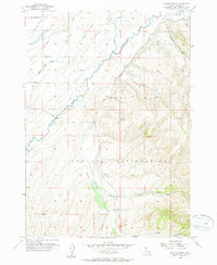
The Fort Hall Indian Reservation landscape is defined by the complex water engineering of the Lincoln Creek Valley in the mid-1950s. This survey illustrates a sophisticated network of irrigation and drainage infrastructure including the Weeding Lane Reservation Canal, Presto Ditch, and Taylor Ditch that divert water across the flats toward the Blackfoot River. These man-made channels intermingle with natural features like the Eastern Idaho Slough and Lincoln Creek. A significant archaeological and historical marker, the Fort Hall No. 2 Historic Site, is situated along the creek, providing a clear point of reference for the region's 19th-century frontier history. Family-named infrastructure such as Tanner Lane and Cosgrove Road suggests the established agricultural footprint of the era.
23 named features on this map. Tap any name to fly to it.
Don’t see what you’re looking for? This feature index may not catch every label — zoom into the map to look around manually.
2 editions found
71 maps found

1917 Cranes Flat
Bingham County, ID

1918 Paradise Valley
Bingham County, ID

1950 Goshen
Bingham County, ID

1951 Higham Peak
Bingham County, ID

1952 Goshen
Bingham County, ID

1955 Baldy Knoll
Bingham County, ID

1955 Lincoln Creek
Bingham County, ID

1955 Pingree
Bingham County, ID

1955 Rose
Bingham County, ID

1955 Springfield
Bingham County, ID

1955 Springfield NW
Bingham County, ID

1955 Yandell Springs
Bingham County, ID

1963 Bone
Bingham County, ID

1971 American Falls NW
Bingham County, ID

1971 Buckskin Basin
Bingham County, ID

1973 Big Fill Reservoir
Bingham County, ID

1973 Coffee Point
Bingham County, ID

1973 Coffee Point NE
Bingham County, ID

1973 Coffee Point SW
Bingham County, ID

1973 Lava Lake Reservoir
Bingham County, ID

1973 Little Butte
Bingham County, ID

1973 Little Butte SW
Bingham County, ID

1973 Middle Butte
Bingham County, ID

1973 Olsen
Bingham County, ID

1973 Rock Butte
Bingham County, ID

1973 Taber
Bingham County, ID

1973 Taber NE
Bingham County, ID

1981 Dunn Basin
Bingham County, ID

1981 Lincoln Peak
Bingham County, ID

1981 Long Valley
Bingham County, ID

1981 Meadow Creek Mtn
Bingham County, ID

1981 Miner Creek
Bingham County, ID

1981 Paradise Valley
Bingham County, ID

1981 Poison Creek
Bingham County, ID

1981 Wolverine
Bingham County, ID

1981 Yandell Springs
Bingham County, ID

1998 Goshen
Bingham County, ID

1998 Higham Peak
Bingham County, ID

1998 Lincoln Creek
Bingham County, ID

2023 American Falls NW
Bingham County, ID

2023 Baldy Knoll
Bingham County, ID

2023 Big Fill Reservoir
Bingham County, ID

2023 Bone
Bingham County, ID

2023 Buckskin Basin
Bingham County, ID

2023 Coffee Point
Bingham County, ID

2023 Coffee Point NE
Bingham County, ID

2023 Coffee Point SW
Bingham County, ID

2023 Goshen
Bingham County, ID

2023 Lava Lake Reservoir
Bingham County, ID

2023 Lincoln Creek
Bingham County, ID

2023 Lincoln Peak
Bingham County, ID

2023 Little Butte
Bingham County, ID

2023 Little Butte SW
Bingham County, ID

2023 Long Valley
Bingham County, ID

2023 Middle Butte
Bingham County, ID

2023 Miner Creek
Bingham County, ID

2023 Pingree
Bingham County, ID

2023 Poison Creek
Bingham County, ID

2023 Rose
Bingham County, ID

2023 Springfield NW
Bingham County, ID

2023 Taber
Bingham County, ID

2023 Taber NE
Bingham County, ID

2023 Wolverine
Bingham County, ID

2023 Yandell Springs
Bingham County, ID

2024 Dunn Basin
Bingham County, ID

2024 Higham Peak
Bingham County, ID

2024 Meadow Creek Mountain
Bingham County, ID

2024 Olsen
Bingham County, ID

2024 Paradise Valley
Bingham County, ID

2024 Rock Butte
Bingham County, ID

2024 Springfield
Bingham County, ID