
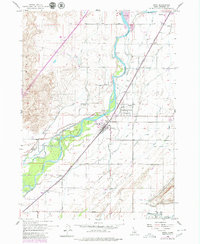
1955 Map of Firth
USGS Topo · Published 1957About this map
The Snake River corridor in Bingham County serves as the lifeblood of this mid-century landscape, fueling a complex irrigation network of canals and ditches. The communities of Firth, Basalt, and Shelley are linked by the Union Pacific railroad and Highway 91-191, which run parallel to the river's eastern bank. A distinctive geological transition is visible on the western side of the river, where the lava fields of the Snake River Plain dominate the terrain, contrasting sharply with the fertile, canal-fed agricultural land to the east.
Find a feature on this map
51 named features on this map. Tap any name to fly to it.
Don’t see what you’re looking for? This feature index may not catch every label — zoom into the map to look around manually.
Map Details
Editions of this 1955 Firth Map
2 editions found
Other maps of this area

1940 · Blackfoot
USGS Topo · 1:62,500

1943 · Blackfoot
USGS Topo · 1:62,500

1948 · Woodville
USGS Topo · 1:24,000

1948 · Idaho Falls South
USGS Topo · 1:24,000

1950 · Woodville
USGS Topo · 1:24,000

1950 · Idaho Falls South
USGS Topo · 1:24,000

1950 · Goshen
USGS Topo · 1:24,000

1951 · Higham Peak
USGS Topo · 1:24,000

1952 · Goshen
USGS Topo · 1:24,000

1955 · Lincoln Creek
USGS Topo · 1:24,000