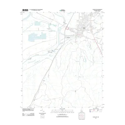
2012 Map of Yazoo City
USGS Topo · Published 2012About this map
Yazoo City serves as the focal point for this area along the winding banks of the Yazoo River, where the landscape is defined by its deep relationship with the waterway. The presence of the Yazoo City Cut-Off 1940 indicates significant mid-twentieth-century engineering to manage the river's flow. A dense network of landings, including Inchucka Landing, Elmwood Landing, and Mcgruders Landing, reflects a long history of river-based commerce and transportation that once sustained these Delta communities.
Find a feature on this map
117 named features on this map. Tap any name to fly to it.
Don’t see what you’re looking for? This feature index may not catch every label — zoom into the map to look around manually.
Map Details
Editions of this 2012 Yazoo City Map
This is the sole edition of this map. No revisions or reprints were ever made.
Other maps of this area

1940 · Mechanicsburg
USGS Topo · 1:62,500

1955 · Jackson
USGS Topo · 1:250,000

1961 · Jackson
USGS Topo · 1:250,000

1961 · Bayland
USGS Topo · 1:62,500

1961 · Valley
USGS Topo · 1:62,500

1962 · Jackson
USGS Topo · 1:250,000

1962 · Flora
USGS Topo · 1:62,500

1963 · Mechanicsburg
USGS Topo · 1:62,500

1984 · Yazoo City
USGS Topo · 1:100,000
1988 · Eden
USGS Topo · 1:24,000