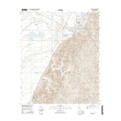
2015 Map of Yazoo City
USGS Topo · Published 2015About this map
Yazoo City sits at the junction of the Mississippi Delta and the loess bluffs, a landscape defined by significant hydrological engineering. The presence of the Yazoo City Cut-Off 1949 and the Jonestown Cut-Off illustrates a mid-century effort to tame the meandering Yazoo River and manage the floodwaters of Tokeba Bayou. To the south, the terrain rises sharply from the flat alluvial plain into the dissected hills of Center Ridge, where small rural communities like Crupp and Valley are situated along winding roads like Old MS 49.
Find a feature on this map
106 named features on this map. Tap any name to fly to it.
Don’t see what you’re looking for? This feature index may not catch every label — zoom into the map to look around manually.
Map Details
Editions of this 2015 Yazoo City Map
This is the sole edition of this map. No revisions or reprints were ever made.
Other maps of this area

1940 · Mechanicsburg
USGS Topo · 1:62,500

1955 · Jackson
USGS Topo · 1:250,000

1961 · Jackson
USGS Topo · 1:250,000

1961 · Bayland
USGS Topo · 1:62,500

1961 · Valley
USGS Topo · 1:62,500

1962 · Jackson
USGS Topo · 1:250,000

1962 · Flora
USGS Topo · 1:62,500

1963 · Mechanicsburg
USGS Topo · 1:62,500

1984 · Yazoo City
USGS Topo · 1:100,000
1988 · Eden
USGS Topo · 1:24,000