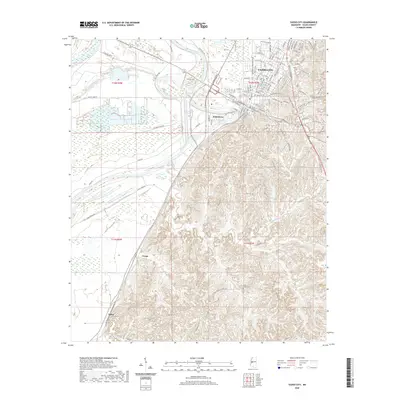
2020 Map of Yazoo City
USGS Topo · Published 2020About this map
Yazoo City and the fertile lowlands of the Yazoo River delta dominate this 2020 landscape. The map illustrates the town's position at the transition between the river's winding course and the sharp elevation of the bluff line to the east. Modern infrastructure such as the Haley Barbour Pkwy and S Industrial Pkwy reflect the region's contemporary economic layout, while the Yazoo County Courthouse serves as a central civic landmark.
Find a feature on this map
121 named features on this map. Tap any name to fly to it.
Don’t see what you’re looking for? This feature index may not catch every label — zoom into the map to look around manually.
Map Details
Editions of this 2020 Yazoo City Map
This is the sole edition of this map. No revisions or reprints were ever made.
Other maps of this area

1940 · Mechanicsburg
USGS Topo · 1:62,500

1955 · Jackson
USGS Topo · 1:250,000

1961 · Jackson
USGS Topo · 1:250,000

1961 · Bayland
USGS Topo · 1:62,500

1961 · Valley
USGS Topo · 1:62,500

1962 · Jackson
USGS Topo · 1:250,000

1962 · Flora
USGS Topo · 1:62,500

1963 · Mechanicsburg
USGS Topo · 1:62,500

1984 · Yazoo City
USGS Topo · 1:100,000
1988 · Eden
USGS Topo · 1:24,000