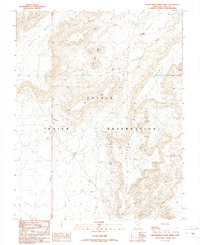
1989 Map of Yellow Rock Point West
USGS Topo · Published 1989About this map
Navajo Indian Reservation lands dominate this late twentieth-century landscape, where industrial energy extraction meets high desert mesas. The map documents a sparse but deliberate network of Oil Wells, Tanks, and Drill Holes scattered across the arid terrain of White Mesa and the plateau simply labeled Mesa. This industrial footprint is interspersed among prominent geological formations like Three Gray Hills and the striking Yellow Rock Point. Water sources are critical but intermittent features of the area, defined by the drainage patterns of Rough Canyon Creek and Tsitah Wash, along with several isolated Wells that serve as vital landmarks for navigation and local ranching in this portion of San Juan County.
Find a feature on this map
17 named features on this map. Tap any name to fly to it.
Don’t see what you’re looking for? This feature index may not catch every label — zoom into the map to look around manually.
Map Details
Editions of this 1989 Yellow Rock Point West Map
This is the sole edition of this map. No revisions or reprints were ever made.
Other maps of this area

1886 · Abajo
USGS Topo · 1:250,000

1892 · Abajo
USGS Topo · 1:250,000

1892 · Canyon De Chelly
USGS Topo · 1:250,000

1893 · Abajo
USGS Topo · 1:250,000

1953 · Pastora Peak NW
USGS Topo · 1:24,000

1953 · Dinne Mesa NE
USGS Topo · 1:24,000

1953 · Pastora Peak NE
USGS Topo · 1:24,000

1953 · Pastora Peak
USGS Topo · 1:62,500

1953 · Toh-Atin Mesa
USGS Topo · 1:62,500

1954 · Shiprock
USGS Topo · 1:250,000