
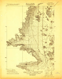
1932 Map of Yreka
USGS Topo · Published 1932About this map
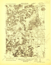
The Klamath River and Scott River systems define this northern California landscape, which was actively being surveyed in the early 1930s. The map illustrates a region transitioning from a frontier mining economy to established agricultural centers. Mining operations such as the Sterling Mine, Cinnabar Mine, and Scorpion Mine are scattered across the peaks of Klamath National Forest, while the valley floors support a dense network of local education, evidenced by the Shasta River Sch, Delphic Sch, and Meamber Sch. The Pacific Highway and Southern Pacific railroad corridor through Shasta Valley connect the larger settlements of Yreka, Montague, and Grenada. In the west, Scott Valley hosts the communities of Fort Jones, Greenview, and Etna, showing a distinct settlement pattern centered on fertile lands and early road networks during this interwar period.
Find a feature on this map
69 named features on this map. Tap any name to fly to it.
Don’t see what you’re looking for? This feature index may not catch every label — zoom into the map to look around manually.
Map Details
Editions of this 1932 Yreka Map
This is the sole edition of this map. No revisions or reprints were ever made.
Other maps of this area

1886 · Shasta
USGS Topo · 1:250,000

1891 · Ashland
USGS Topo · 1:250,000

1893 · Ashland
USGS Topo · 1:250,000

1894 · Shasta
USGS Topo · 1:250,000

1897 · Ashland
USGS Topo · 1:250,000

1908 · Grants Pass
USGS Topo · 1:125,000

1914 · Seiad
USGS Topo · 1:125,000

1921 · Shasta Valley Sheet No 7
USGS Topo · 1:24,000
1921 · Shasta Valley Sheet No 1
USGS Topo · 1:24,000
1921 · Shasta Valley Sheet No 6
USGS Topo · 1:24,000