
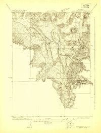
1921 Map of Shasta Valley Sheet No 1
USGS Topo · Published 1921About this map
Gazelle serves as the focal point of this 1921 advance survey, situated where the valley floor meets the steep western foothills in Siskiyou, California. The map illustrates a critical transportation corridor during the early 20th century, dominated by the Southern Pacific (Shasta Route) railroad and the parallel Pacific Highway. These routes trace the narrow level ground between the hills and Willow Creek, capturing the infrastructure that connected the Pacific Northwest to California. The topography is meticulously detailed with five-foot contour intervals, revealing a landscape of small volcanic mounds and complex drainage patterns. Surveyed by L.O.Newsome in cooperation with the U.S. Reclamation Service, the sheet reflects an era focused on regional water management and irrigation potential within the Shasta Valley.
Find a feature on this map
7 named features on this map. Tap any name to fly to it.
Don’t see what you’re looking for? This feature index may not catch every label — zoom into the map to look around manually.
Map Details
Editions of this 1921 Shasta Valley Sheet No 1 Map
This is the sole edition of this map. No revisions or reprints were ever made.
Other maps of this area

1886 · Shasta
USGS Topo · 1:250,000

1894 · Shasta
USGS Topo · 1:250,000

1921 · Shasta Valley Sheet No 7
USGS Topo · 1:24,000

1921 · Shasta Valley Sheet No 6
USGS Topo · 1:24,000

1921 · Shasta Valley Sheet No 2
USGS Topo · 1:24,000

1922 · Shasta Valley Sheet No 1 S
USGS Topo · 1:24,000

1922 · Shasta Valley Sheet No 3 S
USGS Topo · 1:24,000
1922 · Shasta Valley Sheet No 8
USGS Topo · 1:24,000

1923 · Sawyers Bar
USGS Topo · 1:125,000

1931 · Etna
USGS Topo · 1:96,000