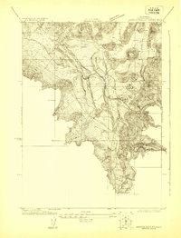
1922 Map of Shasta Valley Sheet No 8
USGS Topo · Published 1922About this map
Edgewood and the nearby settlement of Metcalf occupy a critical transit corridor in the northern California interior during the early 1920s. This survey, conducted by C. A. Stonesifer, captures the infrastructure of a landscape defined by water management and mountain passage. The Southern Pacific railroad and the Shasta Route Highway run nearly parallel through the valley, following the natural contours shaped by the Shasta River and Parks Creek. Notable local landmarks like the Parks Creek School suggest a settled rural community, while the intricate system of the Yreka Ditch and its Ditch Intake reflect the engineering efforts of the U. S. Reclamation Service and local irrigation districts. High-elevation points like Walker overlook the valley, providing a clear view of the topographic complexity where Boles Creek and various springs feed into the larger river system.
Find a feature on this map
16 named features on this map. Tap any name to fly to it.
Don’t see what you’re looking for? This feature index may not catch every label — zoom into the map to look around manually.
Map Details
Editions of this 1922 Shasta Valley Sheet No 8 Map
This is the sole edition of this map. No revisions or reprints were ever made.
Other maps of this area

1886 · Shasta
USGS Topo · 1:250,000

1894 · Shasta
USGS Topo · 1:250,000

1921 · Shasta Valley Sheet No 7
USGS Topo · 1:24,000

1921 · Shasta Valley Sheet No 1
USGS Topo · 1:24,000

1922 · Shasta Valley Sheet No 10
USGS Topo · 1:24,000

1922 · Shasta Valley Sheet No 1 S
USGS Topo · 1:24,000

1922 · Shasta Valley Sheet No 9
USGS Topo · 1:24,000

1923 · Sawyers Bar
USGS Topo · 1:125,000

1931 · Etna
USGS Topo · 1:96,000

1932 · Yreka
USGS Topo · 1:96,000