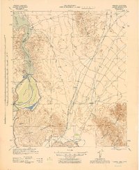
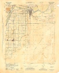
1952 Map of Yuma East
USGS Topo · Published 1953About this map
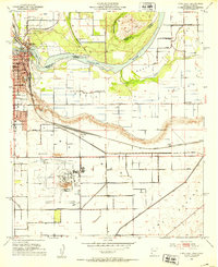
The Colorado River and Gila River converge in this 1952 study, illustrating the complex irrigation and transportation history of the Arizona-California border. The landscape is defined by an extensive network of waterways including the Main Canal, B Canal, and the Yuma Indian Reservation Canal, which support agriculture in the North Gila Valley and South Gila Valley. The map highlights the area's transition from frontier transit to a modern aviation and rail hub. Historical markers such as the Gila Center (Old Stagecoach Station) and the Butterfield Stage Line Probable Route trace the path of early westward travel, while the Southern Pacific railroad and Yuma County Airport represent the era's mid-century infrastructure. Urban Yuma is visible with its Prison Museum, City Cemetery, and numerous local schools, providing a detailed look at the community's civic footprint.
Find a feature on this map
41 named features on this map. Tap any name to fly to it.
Don’t see what you’re looking for? This feature index may not catch every label — zoom into the map to look around manually.
Map Details
Editions of this 1952 Yuma East Map
This is the sole edition of this map. No revisions or reprints were ever made.
Other maps of this area

1903 · Yuma
USGS Topo · 1:125,000

1905 · Yuma
USGS Topo · 1:125,000

1926 · Fortuna
USGS Topo · 1:62,500
1929 · Fortuna
USGS Topo · 1:62,500
1929 · Laguna
USGS Topo · 1:62,500
1940 · Yuma
USGS Topo · 1:62,500

1942 · Yuma
USGS Topo · 1:250,000
1943 · Laguna
USGS Topo · 1:62,500

1945 · Picacho Peak
USGS Topo · 1:62,500
1945 · Yuma
USGS Topo · 1:62,500