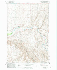
1991 Map of Zangar Junction
USGS Topo · Published 1992About this map
The Walla Walla River carves a winding path through this corner of the Pacific Northwest, where the borders of Washington and Oregon meet. Surveyed in the early 1990s, the map documents a landscape defined by industrial utility and infrastructure. Major utilities are marked by the presence of a substation, a network of pipelines, and telephone lines that cut across the rolling terrain.
Find a feature on this map
17 named features on this map. Tap any name to fly to it.
Don’t see what you’re looking for? This feature index may not catch every label — zoom into the map to look around manually.
Map Details
Editions of this 1991 Zangar Junction Map
This is the sole edition of this map. No revisions or reprints were ever made.
Other maps of this area

1915 · Wallulah
USGS Topo · 1:96,000

1918 · Wallula
USGS Topo · 1:125,000

1935 · Pendleton
USGS Topo · 1:125,000

1953 · Pendleton
USGS Topo · 1:250,000

1953 · Walla Walla
USGS Topo · 1:250,000

1956 · Pendleton
USGS Topo · 1:250,000

1958 · Walla Walla
USGS Topo · 1:250,000

1964 · Wallula
USGS Topo · 1:24,000

1964 · Zangar Junction
USGS Topo · 1:24,000

1964 · Slater
USGS Topo · 1:24,000