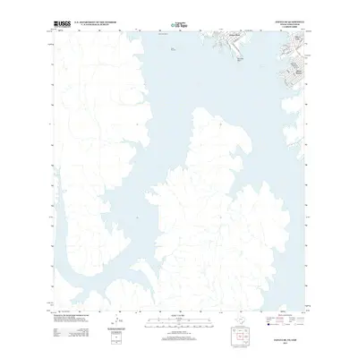
2012 Map of Zapata SE
USGS Topo · Published 2012About this map
Falcon Reservoir dominates this landscape along the Rio Grande, shaping the modern border communities of southern Zapata County. The residential growth at Falcon Mesa and Siesta Shores reflects the 21st-century development of the shoreline, where a network of local roads like Ranch Road 3074 and Loma Dr serve residents and visitors alike. Navigation on the water is clearly delineated by markers such as Buoy Number 1 and Buoy Number 2, which guide craft through the expansive waters of the reservoir. The presence of Paradise Point and the adjacent Falcon Lake settlement highlights the region's reliance on the reservoir for recreation and local utility. This map captures the intricate shoreline of the reservoir, showing how the rising waters have created a series of peninsulas and inlets that define the local geography and residential layout.
Find a feature on this map
25 named features on this map. Tap any name to fly to it.
Don’t see what you’re looking for? This feature index may not catch every label — zoom into the map to look around manually.
Map Details
Editions of this 2012 Zapata SE Map
This is the sole edition of this map. No revisions or reprints were ever made.
Other maps of this area

1938 · Falcon
USGS Topo · 1:62,500

1949 · Mc Allen
USGS Topo · 1:250,000

1954 · McAllen
USGS Topo · 1:250,000

1956 · Zapata
USGS Topo · 1:62,500

1956 · Arroyo Clareno
USGS Topo · 1:62,500

1957 · Mc Allen
USGS Topo · 1:250,000

1962 · McAllen
USGS Topo · 1:250,000
1965 · Beckwith Arm
USGS Topo · 1:24,000
1979 · Zapata
USGS Topo · 1:24,000
1979 · Zapata SE
USGS Topo · 1:24,000