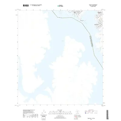
2019 Map of Zapata SE
USGS Topo · Published 2019About this map
The expansive Falcon Reservoir dominates this borderland landscape in South Texas, where the international boundary between the United States of America and Mexico runs directly through the center of the water. On the Texas side, the shoreline is defined by residential developments and leisure communities that emerged to take advantage of the reservoir's recreational potential. These include Falcon Mesa, Falcon Lake Estates, and Siesta Shores, each featuring a dense network of local roads such as Siesta Ln and Yucca Dr. A prominent topographical feature, Paradise Point, juts into the reservoir near the junction of FM 3074, providing a clear view of the water's role in the regional geography. The map reflects a modern era of settlement where residential growth is tightly clustered along the eastern bank, contrasting with the open expanse of the binational lake.
Find a feature on this map
29 named features on this map. Tap any name to fly to it.
Don’t see what you’re looking for? This feature index may not catch every label — zoom into the map to look around manually.
Map Details
Editions of this 2019 Zapata SE Map
This is the sole edition of this map. No revisions or reprints were ever made.
Other maps of this area

1938 · Falcon
USGS Topo · 1:62,500

1949 · Mc Allen
USGS Topo · 1:250,000

1954 · McAllen
USGS Topo · 1:250,000

1956 · Zapata
USGS Topo · 1:62,500

1956 · Arroyo Clareno
USGS Topo · 1:62,500

1957 · Mc Allen
USGS Topo · 1:250,000

1962 · McAllen
USGS Topo · 1:250,000
1965 · Beckwith Arm
USGS Topo · 1:24,000
1979 · Zapata
USGS Topo · 1:24,000
1979 · Zapata SE
USGS Topo · 1:24,000