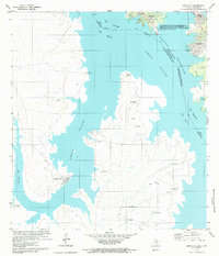
1979 Map of Zapata SE
USGS Topo · Published 1979About this map
The International Jurisdictional Line bisects Falcon Reservoir, marking the aqueous border where the Rio Grande Rio Bravo flows between Texas and Tamaulipas. In this late 1970s landscape, the map captures a significant cross-border geography, detailing both American and Mexican shorelines. On the Texas side, developments like Falcon Mesa and Siesta Shores sit near the reservoir's northern reaches, while the Mexican side features a scattering of settlements such as Miragua, San Angelo, and Solomoneño.
Find a feature on this map
28 named features on this map. Tap any name to fly to it.
Don’t see what you’re looking for? This feature index may not catch every label — zoom into the map to look around manually.
Map Details
Editions of this 1979 Zapata SE Map
This is the sole edition of this map. No revisions or reprints were ever made.
Other maps of this area

1938 · Falcon
USGS Topo · 1:62,500

1949 · Mc Allen
USGS Topo · 1:250,000

1954 · McAllen
USGS Topo · 1:250,000

1956 · Zapata
USGS Topo · 1:62,500

1956 · Arroyo Clareno
USGS Topo · 1:62,500

1957 · Mc Allen
USGS Topo · 1:250,000

1962 · McAllen
USGS Topo · 1:250,000
1965 · Beckwith Arm
USGS Topo · 1:24,000
1979 · Zapata
USGS Topo · 1:24,000
1979 · Zapata NW
USGS Topo · 1:24,000
Featured Places
- Siesta Shores 3 Colonia, TX
- Falcon Lake Estates, TX
- Lago Halcon B Colonia, TX
- Falcon Lake, TX
- Siesta Shores 1 Colonia, TX