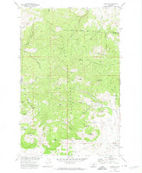
1971 Map of Zortman
USGS Topo · Published 1974About this map
Zortman and Landusky anchor this 1971 study of the Little Rocky Mountains, illustrating a landscape defined by its deep mining heritage. Numerous claims and shafts pierce the terrain, including the Ruby Mine, August Mine, and Linda K Mine, reflecting decades of extraction in the hills above Ruby Gulch. The map captures the interface between industrial activity and natural landmarks, showing the proximity of the Camp Creek Campground to active workings. The northern portion of the sheet is bounded by the Fort Belknap Indian Reservation Boundary, while the higher elevations are marked by distinctive peaks such as Shell Butte and Antoine Butte. Geologic and recreational interests intersect at sites like Azure Cave and Two Hands Cave, while the presence of a Landing Strip near the southeastern edge suggests the area's continued reliance on specialized transport networks during this era of Montana's history.
Find a feature on this map
53 named features on this map. Tap any name to fly to it.
Don’t see what you’re looking for? This feature index may not catch every label — zoom into the map to look around manually.
Map Details
Editions of this 1971 Zortman Map
This is the sole edition of this map. No revisions or reprints were ever made.
Other maps of this area

1943 · Landusky
USGS Topo · 1:125,000

1953 · Havre
USGS Topo · 1:250,000

1954 · Lewistown
USGS Topo · 1:250,000

1957 · Havre
USGS Topo · 1:250,000

1958 · Havre
USGS Topo · 1:250,000

1959 · Lewistown
USGS Topo · 1:250,000

1971 · Bear Mountain
USGS Topo · 1:24,000

1971 · Hays
USGS Topo · 1:24,000

1971 · Robinson School
USGS Topo · 1:24,000

1971 · Hays SE
USGS Topo · 1:24,000
Featured Places
- Lodge Pole, Lodge Pole District
- Hays, Hays District
- Lodge Pole District, MT
- Hays District, MT
- Landusky, MT