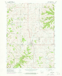
1962 Map of Zwingle
USGS Topo · Published 1973About this map
Zwingle and La Motte anchor this rural landscape along the Dubuque Co Jackson Co border, where the terrain is deeply etched by Lytle Creek and Otter Creek. A notable feature for local historians is the Old Railroad Grade cutting through the center of the sheet, tracing a transit corridor that once linked these small agricultural communities. The map captures a high density of rural institutions, including St Theresa Ch, Assumption Ch, and Holy Rosary Cem, suggesting a community closely tied to its parish centers.
Find a feature on this map
25 named features on this map. Tap any name to fly to it.
Don’t see what you’re looking for? This feature index may not catch every label — zoom into the map to look around manually.
Map Details
Editions of this 1962 Zwingle Map
2 editions found

Other maps of this area

1891 · Maquoketa
USGS Topo · 1:62,500

1891 · Baldwin
USGS Topo · 1:62,500

1901 · Peosta
USGS Topo · 1:125,000

1935 · East Dubuque
USGS Topo · 1:62,500

1940 · East Dubuque
USGS Topo · 1:62,500

1955 · Menominee
USGS Topo · 1:24,000

1955 · Dubuque South
USGS Topo · 1:24,000

1959 · Dubuque
USGS Topo · 1:250,000

1961 · Dubuque
USGS Topo · 1:250,000

1962 · Dubuque
USGS Topo · 1:250,000