2000-2009 Maps of Federated States of Micronesia
Explore 5 historic maps of Federated States of Micronesia from 2000-2009. These maps offer a rare glimpse into what life looked like during the 2000s — showing old roads, neighborhoods, homes, and landmarks that have changed or disappeared over time.
Whether you're researching your family's past, planning a metal detecting trip, or studying how Federated States of Micronesia's landscape evolved across the 2000s, these high-resolution maps are a powerful tool for exploring the history of this region.
- Focus on a specific era: All maps on this page are from the 2000s, giving you a focused view of this time period.
- See what’s changed: Compare century-old streets, trails, and buildings to today's modern landscape using overlays and satellite layers.
- Research with precision: Use these maps for genealogy, historical research, land use analysis, or educational projects.
- View, download, or print: Maps are fully viewable online in high resolution, and can be downloaded or printed for your own records.
Start exploring Federated States of Micronesia's history through authentic maps from the 2000s. This is your window into the past.
Federated States of Micronesia maps
(5)- 2001 Map of Island Of Pohnpei (Southwest), 2002 Print
 2001 Island Of Pohnpei (Southwest)2002 Print · USGSThe southwestern coast of Pohnpei is captured here at the start of the millennium, showing a landscape defined by its protected marine zones and forest reserves. Researchers can trace the coastal settlements of Sekeren and Wenik or locate landmarks like the southern Dispensary.
 - 2001 Map of Island Of Pohnpei (Northeast), 2002 Print
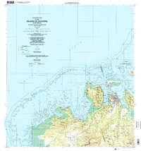
 2001 Island Of Pohnpei (Northeast)2002 Print · USGSNortheastern Pohnpei in the early 2000s showcases a balance of village life and vital maritime conservation areas. Researchers can trace traditional coastal settlements like Kepin Ketiwo and Nindol alongside the Dehpehk Marine Sanctuary and the islands of Deke Awah.
 - 2001 Map of Island Of Pohnpei (Northwest), 2002 Print
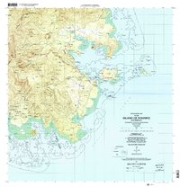
 2001 Island Of Pohnpei (Northwest)2002 Print · USGSNorthwest Pohnpei at the turn of the millennium showcases the expansion of Kolonia alongside protected natural reaches. Researchers can trace the development of the Pohnpei International Airport and locate traditional settlements like Sapwawas and Palikir.
 - 2001 Map of Island Of Pohnpei (Southeast), 2002 Print
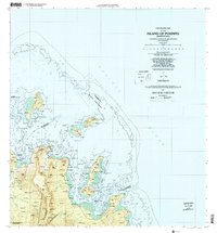
 2001 Island Of Pohnpei (Southeast)2002 Print · USGSSoutheastern Pohnpei at the opening of the millennium shows a landscape where protected forest reserves meet thriving coastal reef systems. Researchers can trace local settlements from Dolrakied to Lohd Pawe and locate marine protected areas like the Namwen Na Na Marine Sanctuary.
 - 2001 Map of Island of Kosrae, 2004 Print
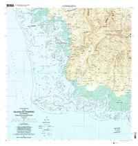
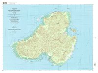 2001 Island of Kosrae2004 Print · USGSMicronesian island life at the start of the twenty-first century is captured here, showing the balance between modern infrastructure and protected wilderness. Researchers can trace coastal villages from Tafunsak to Malem or locate landmarks like Lelu Island and the Walung Elementary School.
End of results
Showing maps 1-5 of 5
Top cities of Federated States of Micronesia
Frequently asked questions
- What are the different types of historical maps available for Federated States of Micronesia?
- What is the oldest map of Federated States of Micronesia?
- Where can I purchase historical maps of Federated States of Micronesia for my home or office?
- Where can I download high-res historical maps of Federated States of Micronesia?
- Are there historical topographic maps available for Federated States of Micronesia?
- Is there historical aerial imagery available for Federated States of Micronesia?
- Where are historical maps of Federated States of Micronesia sourced from?