Old Maps of Federated States of Micronesia for Metal Detecting
Plan your next treasure hunt with 19 historic maps of Federated States of Micronesia. Find old homesites, ghost towns, trails, and gathering spots that may be lost to time — perfect for identifying promising metal detecting locations.
- Locate forgotten sites: Uncover places like long-lost settlements, abandoned rail lines, or gathering spots.
- Plan better hunts: Use map overlays combined with LiDAR or satellite views to narrow in on historically rich areas.
- Made for detectorists: Thousands of hobbyists use these maps to discover relics, coins, and hidden history.
Use these historic maps to boost your research and find new opportunities beneath the surface of Federated States of Micronesia.
Federated States of Micronesia maps
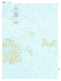
(19)- 1983 Map of Yap Islands (Waqab)
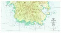
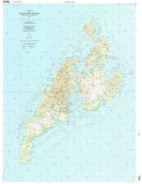
 1983 Yap Islands (Waqab)1983 Print · USGSThe Yap Islands are captured in the early eighties as they transitioned into a new era of self-governance. Researchers can trace traditional village sites like Gagnagun and Bechiyal or locate landmarks such as St Josephs Church and the Yap Airport.
 - 1983 Map of Unikappi
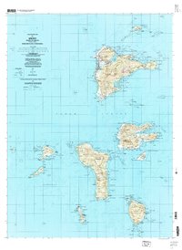
 1983 Unikappi1983 Print · USGSMicronesia's island geography is detailed here in the early eighties, showing the traditional settlements of the eastern lagoon. Genealogists and researchers can trace the coastal villages of Unikappi, Nepuachechen, and the isolated islet of Onamue.
 - 1983 Map of Island Of Ponape (North Half)
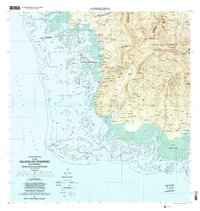
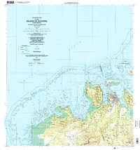
 1983 Island Of Ponape (North Half)1983 Print · USGSThe northern coast of Ponape in the early eighties shows the administrative center of Kolonia amidst a landscape of steep volcanic peaks and vast coral reefs. Genealogists and researchers can trace local settlements like Palikir and Ohwa or locate landmarks such as the Radio Towers.
 - 1983 Map of Island Of Ponape (South Half)
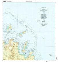
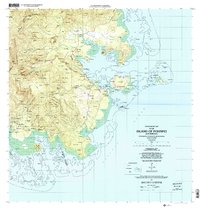
 1983 Island Of Ponape (South Half)1983 Print · USGSMicronesia’s southern coastlines and interior peaks are recorded here in the early 1980s, shortly after the formation of the Federated States. Researchers can trace coastal villages from Pahn Kiper to Tomwara and the essential local Dispensary.
 - 1996 Map of Yap Islands (Waqab), 2003 Print
 1996 Yap Islands (Waqab)2003 Print · USGSThe Yap Islands in the mid-1990s show a blend of traditional village life and modern infrastructure across the Federated States of Micronesia. Researchers can trace the coastal layout of Colonia, locate specific mission sites like Saint Joseph Church, and find historic Fish Traps near Wanyan.
 - 1996 Map of Neoch, 2004 Print
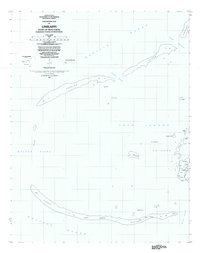
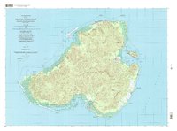
 1996 Neoch2004 Print · USGSThe remote atoll of Neoch in the Chuuk State is detailed here in the late twentieth century, showing the isolation of these Micronesian islands. Researchers can trace the perimeter of the coral reef to find small landforms like Feneppi, Ipis, and Fanait.
 - 1996 Map of Meseong, 2004 Print
 1996 Meseong2004 Print · USGSThe atolls of Micronesia's Chuuk Lagoon are captured here in the mid-nineties, showing the delicate balance of land and sea. Researchers can locate the settlement at Meseong, identify historical Ruins, and trace maritime passages like Mochun Neuri and Mochun Fein.
 - 1996 Map of Tol South, 2004 Print
 1996 Tol South2004 Print · USGSChuuk Lagoon and its southern reef systems are captured here in the mid-1990s as part of the Federated States of Micronesia. Researchers can trace the isolated geography of remote islets like Onnang, Onno, and the reef passage at Mochun Nepis.
 - 1997 Map of Unikappi, 2003 Print
 1997 Unikappi2003 Print · USGSThe islands of Pata and Polle are shown in high detail during the late twentieth century as they appeared within the Chuuk Lagoon. Researchers can trace the layout of small settlements like Unikappi, Wichap, and Pukuan along with several local schools.
 - 1997 Map of Tol, 2003 Print
 1997 Tol2003 Print · USGSThe islands of Faichuk are mapped here in the late twentieth century, showing the intricate settlement patterns across Chuuk Lagoon. Genealogists and historians can trace local centers like Wichuk, Winisi, and Fanapenges alongside trails and schools.
 - 1997 Map of Wonno, 2004 Print
 1997 Wonno2004 Print · USGSChuuk Lagoon and its surrounding reefs appear in this late twentieth-century survey of the Nomoneas island group. Researchers can identify isolated settlements and reef landmarks like Wonno, the Ochoeor reef line, and Ruins near Anangerimon.
 - 1997 Map of Piis Moen, 2004 Print
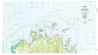
 1997 Piis Moen2004 Print · USGSThe northern atolls of the Federated States of Micronesia come into focus in the late nineties, showing the delicate balance of life on the edge of the lagoon. Researchers can trace local settlements from Nukan to Wilton and the maritime passages of Mochonap.
 - 1997 Map of Weno, 2004 Print
 1997 Weno2004 Print · USGSChuuk Lagoon in the late nineties is presented here through the detailed geography of Weno and its surrounding volcanic islands. Genealogists and researchers can locate coastal settlements like Mechitiw and Sapuk, alongside schools such as Chuuk High Sch.
 - 1997 Map of Ruo, 2004 Print
 1997 Ruo2004 Print · USGSThe Northeast Islands of Chuuk State appear in fine detail during the late nineties, documenting isolated reef settlements. Genealogists and researchers can trace local island life through locations like Ruo, Sopweru, and the North Bm 2 Ruins.
 - 2001 Map of Island Of Pohnpei (Southwest), 2002 Print
 2001 Island Of Pohnpei (Southwest)2002 Print · USGSThe southwestern coast of Pohnpei is captured here at the start of the millennium, showing a landscape defined by its protected marine zones and forest reserves. Researchers can trace the coastal settlements of Sekeren and Wenik or locate landmarks like the southern Dispensary.
 - 2001 Map of Island Of Pohnpei (Northeast), 2002 Print
 2001 Island Of Pohnpei (Northeast)2002 Print · USGSNortheastern Pohnpei in the early 2000s showcases a balance of village life and vital maritime conservation areas. Researchers can trace traditional coastal settlements like Kepin Ketiwo and Nindol alongside the Dehpehk Marine Sanctuary and the islands of Deke Awah.
 - 2001 Map of Island Of Pohnpei (Northwest), 2002 Print
 2001 Island Of Pohnpei (Northwest)2002 Print · USGSNorthwest Pohnpei at the turn of the millennium showcases the expansion of Kolonia alongside protected natural reaches. Researchers can trace the development of the Pohnpei International Airport and locate traditional settlements like Sapwawas and Palikir.
 - 2001 Map of Island Of Pohnpei (Southeast), 2002 Print
 2001 Island Of Pohnpei (Southeast)2002 Print · USGSSoutheastern Pohnpei at the opening of the millennium shows a landscape where protected forest reserves meet thriving coastal reef systems. Researchers can trace local settlements from Dolrakied to Lohd Pawe and locate marine protected areas like the Namwen Na Na Marine Sanctuary.
 - 2001 Map of Island of Kosrae, 2004 Print
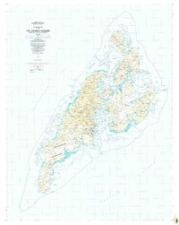
 2001 Island of Kosrae2004 Print · USGSMicronesian island life at the start of the twenty-first century is captured here, showing the balance between modern infrastructure and protected wilderness. Researchers can trace coastal villages from Tafunsak to Malem or locate landmarks like Lelu Island and the Walung Elementary School.
End of results
Showing maps 1-19 of 19
Top cities of Federated States of Micronesia
Frequently asked questions
- What are the different types of historical maps available for Federated States of Micronesia?
- What is the oldest map of Federated States of Micronesia?
- Where can I purchase historical maps of Federated States of Micronesia for my home or office?
- Where can I download high-res historical maps of Federated States of Micronesia?
- Are there historical topographic maps available for Federated States of Micronesia?
- Is there historical aerial imagery available for Federated States of Micronesia?
- Where are historical maps of Federated States of Micronesia sourced from?