Old Maps of Malem, Kosrae for Genealogy
Trace your family roots with 1 historic maps of Malem. These high-res maps reveal old neighborhoods, homesites, landmarks, and streets — helping you uncover where your ancestors lived and how the area evolved over time.
- Explore historic neighborhoods: Identify where your relatives may have lived in the 1800s or 1900s.
- Compare maps over time: Trace the changes in streets, buildings, and landmarks for multi-generational research.
- Perfect for genealogy & ancestry research: Used by family historians and researchers to map out lineage and migration.
These maps are an incredible resource for exploring your personal connection to Malem's past.
Malem, KSA maps
(1)- 2001 Map of Island of Kosrae, 2004 Print
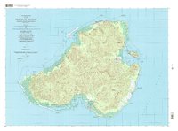 2001 Island of Kosrae2004 Print · USGSMicronesian island life at the start of the twenty-first century is captured here, showing the balance between modern infrastructure and protected wilderness. Researchers can trace coastal villages from Tafunsak to Malem or locate landmarks like Lelu Island and the Walung Elementary School.
End of results
Showing maps 1-1 of 1
Frequently asked questions
- What are the different types of historical maps available for Malem?
- What is the oldest map of Malem?
- Where can I purchase historical maps of Malem for my home or office?
- Where can I download high-res historical maps of Malem?
- Are there historical topographic maps available for Malem?
- Is there historical aerial imagery available for Malem?
- Where are historical maps of Malem sourced from?