Old Maps of Malem, Kosrae for Metal Detecting
Plan your next treasure hunt with 1 historic maps of Malem. Find old homesites, ghost towns, trails, and gathering spots that may be lost to time — perfect for identifying promising metal detecting locations.
- Locate forgotten sites: Uncover places like long-lost settlements, abandoned rail lines, or gathering spots.
- Plan better hunts: Use map overlays combined with LiDAR or satellite views to narrow in on historically rich areas.
- Made for detectorists: Thousands of hobbyists use these maps to discover relics, coins, and hidden history.
Use these historic maps to boost your research and find new opportunities beneath the surface of Malem.
Malem, KSA maps
(1)- 2001 Map of Island of Kosrae, 2004 Print
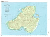 2001 Island of Kosrae2004 Print · USGSMicronesian island life at the start of the twenty-first century is captured here, showing the balance between modern infrastructure and protected wilderness. Researchers can trace coastal villages from Tafunsak to Malem or locate landmarks like Lelu Island and the Walung Elementary School.
End of results
Showing maps 1-1 of 1
Frequently asked questions
- What are the different types of historical maps available for Malem?
- What is the oldest map of Malem?
- Where can I purchase historical maps of Malem for my home or office?
- Where can I download high-res historical maps of Malem?
- Are there historical topographic maps available for Malem?
- Is there historical aerial imagery available for Malem?
- Where are historical maps of Malem sourced from?