Old Maps of Aimeliik for Hiking & Exploration
Hike through history with 4 historic maps of Aimeliik. Explore old trails, ghost towns, and forgotten backroads — perfect for outdoor adventurers and local explorers.
- Rediscover forgotten places: Map out old mining camps, roads, and footpaths that no longer exist on modern maps.
- Layer with modern tools: Combine with LiDAR or satellite views to plan hikes through historical terrain.
- Made for exploration: Popular among hikers, overlanders, and local history lovers.
Use these maps to find adventure and explore the hidden past of Aimeliik.
Aimeliik maps
(4)- 1983 Map of Ngermetengel, 1984 Print
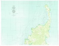 1983 Ngermetengel1984 Print · USGSBabeldaob's northern villages and complex coral reefs are mapped here in the early eighties. Researchers can trace traditional settlements from Ngermetengel up to Ollei, and locate inland features like the Mine near the western coast.
 - 1983 Map of Oreor, 1984 Print
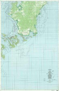 1983 Oreor1984 Print · USGSThe islands of Palau are shown during a period of significant development in the early eighties. Researchers can trace the layout of traditional villages like Ngerkesoaol and Ngermid alongside the site of the Palau Airport.
 - 1984 Map of Chelbacheb
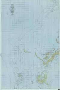 1984 Chelbacheb1984 Print · USGSThe limestone islands of the Palau archipelago are mapped here in the mid-eighties, revealing a complex network of reefs and lagoons. Researchers can chart the boundaries of the Ngerokeuid Wildlife Reservation Area or trace waterways like Klouel Toi and Toachel Belau.
 - 2000 Map of Babeldaob South, 2004 Print
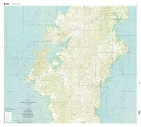 2000 Babeldaob South2004 Print · USGSBabeldaob Island at the turn of the millennium reveals a traditional landscape of coastal villages and protected interior highlands. Researchers can trace the development of settlements like Melekeok and Airai, or locate local landmarks such as the Ngchesar School and the Ngeremeduu Conservation Area.
End of results
Showing maps 1-4 of 4
Frequently asked questions
- What are the different types of historical maps available for Aimeliik?
- What is the oldest map of Aimeliik?
- Where can I purchase historical maps of Aimeliik for my home or office?
- Where can I download high-res historical maps of Aimeliik?
- Are there historical topographic maps available for Aimeliik?
- Is there historical aerial imagery available for Aimeliik?
- Where are historical maps of Aimeliik sourced from?