1930s Maps of Cabo Rojo
Explore 6 historic maps of Cabo Rojo from the 1930s. These maps offer a rare glimpse into what life looked like during the 1930s — showing old roads, neighborhoods, homes, and landmarks that have changed or disappeared over time.
Whether you're researching your family's past, planning a metal detecting trip, or studying how Cabo Rojo's landscape evolved across the 1930s, these high-resolution maps are a powerful tool for exploring the history of this region.
- Focus on a specific era: All maps on this page are from the 1930s, giving you a focused view of this time period.
- See what’s changed: Compare century-old streets, trails, and buildings to today's modern landscape using overlays and satellite layers.
- Research with precision: Use these maps for genealogy, historical research, land use analysis, or educational projects.
- View, download, or print: Maps are fully viewable online in high resolution, and can be downloaded or printed for your own records.
Start exploring Cabo Rojo's history through authentic maps from the 1930s. This is your window into the past.
Cabo Rojo maps
(6)- 1935 Map of Puerto Real
 1935 Puerto Real1935 Print · USGSCoastal Cabo Rojo during the mid-1930s reveals a landscape of salt flats, emerging rail lines, and rural schools. Researchers can trace the path of the American RR of Puerto Rico and locate local landmarks like Las Salinas and Escuela Santiago Negroni.
 - 1937 Map of San German
 1937 San German1937 Print · USGSSan Germán and the surrounding valleys of southwestern Puerto Rico are captured here in the mid-1930s during a period of significant agricultural and educational growth. Researchers can trace ancestral connections through named estates like Hacienda Luisa, local landmarks such as the Polytechnic Institute, and the rail stops of the American Railroad of Puerto Rico.
 - 1937 Map of Puerto Real
 1937 Puerto Real1937 Print · USGSCoastal Cabo Rojo in the mid-1930s reveals a landscape of salt flats and growing settlements along the Mona Passage. Researchers can trace dozens of early rural schools like Escuela Garfield and find family landmarks near Boqueron and the Cemeterio Delicias.
 - 1938 Map of Parguera
 1938 Parguera1938 Print · USGSThe southwestern coast of Puerto Rico is mapped here in the late thirties, before the expansion of its coastal villages. Local historians can trace the early layout of Parguera, the footprint of the Escuela Ramon Baldorioty de Castro, and traditional sites like Salinas El Papayo.4 unique versions available
 - 1938 Map of Cabo Rojo
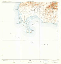 1938 Cabo Rojo1938 Print · USGSThe southwestern tip of Puerto Rico is captured here in the late 1930s, showing the salt-rich coastlines of Bahia Salinas and Bahia Sucia. Genealogists and historians can trace the rural life of the era through sites like Las Palmas and the Escuela Sebastian Pabon Alvarado.5 unique versions available
 - 1939 Map of Mayaguez
 1939 Mayaguez1939 Print · USGSCoastal western Puerto Rico appears in detail during the late 1930s, documenting the vital rail and sugar networks of the era. Genealogists and historians can trace family locations near Colonia Estebanía, visit the Central Rochelaise mill, or follow the American Railroad of Porto Rico.
End of results
Showing maps 1-6 of 6
Frequently asked questions
- What are the different types of historical maps available for Cabo Rojo?
- What is the oldest map of Cabo Rojo?
- Where can I purchase historical maps of Cabo Rojo for my home or office?
- Where can I download high-res historical maps of Cabo Rojo?
- Are there historical topographic maps available for Cabo Rojo?
- Is there historical aerial imagery available for Cabo Rojo?
- Where are historical maps of Cabo Rojo sourced from?