Old Maps of Cabo Rojo for Academic Research
Study the evolution of Cabo Rojo with 44 high-resolution historic maps. Whether you're teaching, researching, or modeling changes in land use, these maps provide essential visual documentation of urban, environmental, and geographic change.
- Analyze long-term change: Track patterns in development, transportation, and natural features.
- Ideal for environmental or urban studies: Support academic projects with primary historical map data.
- Use in the classroom or lab: Educators and researchers rely on these maps to bring historical context to life.
These maps are a powerful tool for teaching, research, and visualizing how Cabo Rojo has changed over the decades.
Cabo Rojo maps
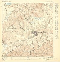
(44)- 1935 Map of Puerto Real
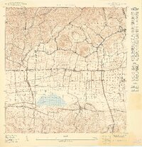
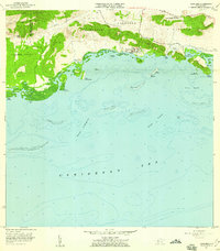
 1935 Puerto Real1935 Print · USGSCoastal Cabo Rojo during the mid-1930s reveals a landscape of salt flats, emerging rail lines, and rural schools. Researchers can trace the path of the American RR of Puerto Rico and locate local landmarks like Las Salinas and Escuela Santiago Negroni.
 - 1937 Map of San German
 1937 San German1937 Print · USGSSan Germán and the surrounding valleys of southwestern Puerto Rico are captured here in the mid-1930s during a period of significant agricultural and educational growth. Researchers can trace ancestral connections through named estates like Hacienda Luisa, local landmarks such as the Polytechnic Institute, and the rail stops of the American Railroad of Puerto Rico.
 - 1937 Map of Puerto Real
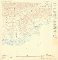
 1937 Puerto Real1937 Print · USGSCoastal Cabo Rojo in the mid-1930s reveals a landscape of salt flats and growing settlements along the Mona Passage. Researchers can trace dozens of early rural schools like Escuela Garfield and find family landmarks near Boqueron and the Cemeterio Delicias.
 - 1938 Map of Parguera
 1938 Parguera1938 Print · USGSThe southwestern coast of Puerto Rico is mapped here in the late thirties, before the expansion of its coastal villages. Local historians can trace the early layout of Parguera, the footprint of the Escuela Ramon Baldorioty de Castro, and traditional sites like Salinas El Papayo.4 unique versions available
 - 1938 Map of Cabo Rojo
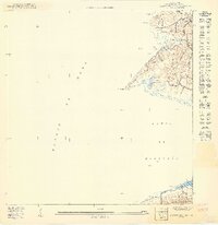
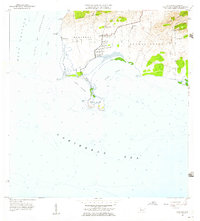
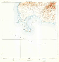 1938 Cabo Rojo1938 Print · USGSThe southwestern tip of Puerto Rico is captured here in the late 1930s, showing the salt-rich coastlines of Bahia Salinas and Bahia Sucia. Genealogists and historians can trace the rural life of the era through sites like Las Palmas and the Escuela Sebastian Pabon Alvarado.5 unique versions available
 - 1939 Map of Mayaguez
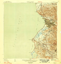
 1939 Mayaguez1939 Print · USGSCoastal western Puerto Rico appears in detail during the late 1930s, documenting the vital rail and sugar networks of the era. Genealogists and historians can trace family locations near Colonia Estebanía, visit the Central Rochelaise mill, or follow the American Railroad of Porto Rico.
 - 1941 Map of San German
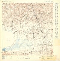
 1941 San German1941 Print · USGSThe hills and valleys surrounding San Germán come alive in this early 1940s survey, showing the peak of the railroad era in southwest Puerto Rico. Researchers can trace the American Railroad of Porto Rico through a landscape of historic estates like Hacienda Beatriz Soledad and Hacienda Resolucion.5 unique versions available
 - 1941 Map of Puerto Real
 1941 Puerto Real1941 Print · USGSCoastal life in southwestern Puerto Rico centered on the harbor at Puerto Real and the rail line at Cabo Rojo during the late thirties and early forties. Local historians can trace the American Railroad corridor and locate old landmarks like Cementerio Delicias and the salt works at Las Salinas.4 unique versions available
 - 1947 Map of Mayaguez
 1947 Mayaguez1947 Print · USGSMayagüez and its thriving coastal economy are documented here in the late thirties, featuring the vital rail links of the American Railroad of Puerto Rico. Trace ancestral roots in Poblado Sabalos, Hormigueros, and along the sugar-rich Colonia Cornelia.4 unique versions available
 - 1949 Map of Puerto Real SE
 1949 Puerto Real SE1949 Print · USGSCabo Rojo’s southwestern coast is documented during the late 1940s, highlighting the rural barrios and coastal hydrology before modern development. Genealogists and historians can trace family locations near Cuatro Caminos, the salt flats of Salinas, and the shores of Laguna Rincón.
 - 1949 Map of Cabo Rojo NE
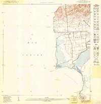
 1949 Cabo Rojo NE1949 Print · USGSThe southwest coast of Puerto Rico is captured in the late 1940s, showing the intersection of salt production and rural life. Trace the early layout of Corozo or find the landmark Iglesia de Cristo Rey near the base of Lomas de Boquerón.
 - 1949 Map of Puerto Real NE
 1949 Puerto Real NE1949 Print · USGSCabo Rojo and the western coast of Puerto Rico are captured here in the late forties, showing the region's transition from rural hills to seaside villages. Genealogists can locate family landmarks like Cementerio Delicias, the Iglesia Católica de Carmen, and the route of the American Railroad Company of Porto Rico.
 - 1949 Map of Puerto Real SO
 1949 Puerto Real SO1949 Print · USGSThe southwestern coast of Puerto Rico is captured here in the late 1940s as a landscape of salt pans and rocky headlands. Genealogists and historians can trace the settlement at Col Cofresi, the industrial Estacion Cantera, and the coastal geography of Laguna Guaniquilla.
 - 1949 Map of Puerto Real NO
 1949 Puerto Real NO1949 Print · USGSCoastal Cabo Rojo is captured in detail during the late 1940s, showing the essential maritime landscape of the western shore. Genealogists and researchers can trace the early layout of Puerto Real and the surrounding barrios of Miradero and Pedernales.
 - 1949 Map of Cabo Rojo NO
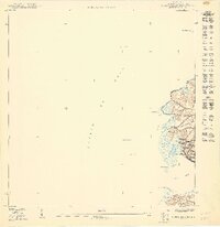
 1949 Cabo Rojo NO1949 Print · USGSThe southwestern tip of Puerto Rico is revealed here in the late 1940s, highlighting the historic salt industry and coastal life. Researchers can trace the layout of Salinas Corozo and Salinas Candelaria or locate the Faro near Pta Jagüey.
 - 1949 Map of San German SO
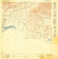
 1949 San German SO1949 Print · USGSSouthwestern Puerto Rico’s agricultural heartland is captured here in the late 1940s, centered on the historic Laguna Cartagena. Researchers can trace the path of the American Railroad of Porto Rico as it served rural estates like Hacienda Desengaño.
 - 1949 Map of Parguera NO
 1949 Parguera NO1949 Print · USGSCoastal Lajas and Cabo Rojo appear here in the late 1940s, highlighting the traditional salt flats and rural landholdings of the southwest shore. Genealogists and historians can locate family landmarks like Rancho Cabassa or trace the geography of Salinas Pitajaya and Isla Guayacán.
 - 1950 Map of Mayaguez SE
 1950 Mayaguez SE1950 Print · USGSCoastal sugar plantations and rail networks dominate the Mayagüez shoreline at the midpoint of the century. Genealogists and historians can trace family-named lands like Colonia García or locate early civic landmarks such as the Escuela Industrial y Reformatoria.
 - 1950 Map of San German NO
 1950 San German NO1950 Print · USGSSouthwestern Puerto Rico at mid-century reveals a landscape of massive sugar haciendas and the early expansion of modern infrastructure. Genealogists and historians can trace the foundations of local barrios through sites like Central Eureka and the Escuela Segunda Unidad de Sabana Eneas.
 - 1955 Map of Mayaguez, 1957 Print
 1955 Mayaguez1957 Print · USGSThe western coast of Puerto Rico comes alive in this mid-century survey of the island's third-largest city. Genealogists and historians can trace the development of Candelaria, locate the Central Rochelaise, or find family sites in Poblado Sábalos.
 - 1957 Map of Cabo Rojo, 1959 Print
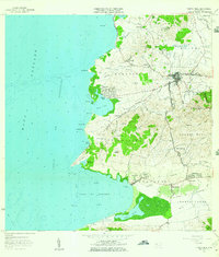
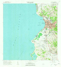
 1957 Cabo Rojo1959 Print · USGSThe tip of southwestern Puerto Rico in the late fifties shows a coastal landscape dominated by salt production and maritime navigation. Genealogists and historians can trace local life through the Escuela Sebastián Pabón Alves and settlements like El Combate and Pole Ojea.
 - 1957 Map of Puerto Real, 1959 Print
 1957 Puerto Real1959 Print · USGSThe Cabo Rojo coastline in the late fifties showcases a landscape of thriving coastal villages and traditional agriculture. Trace the old rail lines of the Ferrocarril and locate family landmarks like the Iglesia de Carmen or the Cementerio Delicias.2 unique versions available
 - 1957 Map of San German, 1959 Print
 1957 San German1959 Print · USGSSan Germán and the surrounding agricultural valleys are captured in the late fifties, showing the transition from traditional rail to modern infrastructure. Researchers can trace historic sugar haciendas like Hacienda Julia or locate local landmarks like the Instituto Politécnico and Laguna Cartagena.
 - 1957 Map of Parguera, 1959 Print
 1957 Parguera1959 Print · USGSThe Lajas coastline comes alive in the late fifties, showing the interplay between salt production and sea. Trace the shoreline of Bahía Fosforescente, locate the Escuela Ramón Baldorioty de Castro, and explore reefs like Arrecife Coral.
 - 1964 Map of Mayaguez, 1966 Print
 1964 Mayaguez1966 Print · USGSMayagüez and its surrounding coastal barrios are shown here in the mid-1960s as the region transitioned through industrial and academic growth. Trace the roots of local institutions like the University or find family landmarks in Hormigueros and Sabanetas.3 unique versions available
Showing maps 1-25 of 44
Frequently asked questions
- What are the different types of historical maps available for Cabo Rojo?
- What is the oldest map of Cabo Rojo?
- Where can I purchase historical maps of Cabo Rojo for my home or office?
- Where can I download high-res historical maps of Cabo Rojo?
- Are there historical topographic maps available for Cabo Rojo?
- Is there historical aerial imagery available for Cabo Rojo?
- Where are historical maps of Cabo Rojo sourced from?