1960s Maps of Cabo Rojo
Explore 5 historic maps of Cabo Rojo from the 1960s. These maps offer a rare glimpse into what life looked like during the 1960s — showing old roads, neighborhoods, homes, and landmarks that have changed or disappeared over time.
Whether you're researching your family's past, planning a metal detecting trip, or studying how Cabo Rojo's landscape evolved across the 1960s, these high-resolution maps are a powerful tool for exploring the history of this region.
- Focus on a specific era: All maps on this page are from the 1960s, giving you a focused view of this time period.
- See what’s changed: Compare century-old streets, trails, and buildings to today's modern landscape using overlays and satellite layers.
- Research with precision: Use these maps for genealogy, historical research, land use analysis, or educational projects.
- View, download, or print: Maps are fully viewable online in high resolution, and can be downloaded or printed for your own records.
Start exploring Cabo Rojo's history through authentic maps from the 1960s. This is your window into the past.
Cabo Rojo maps
(5)- 1964 Map of Mayaguez, 1966 Print
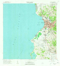 1964 Mayaguez1966 Print · USGSMayagüez and its surrounding coastal barrios are shown here in the mid-1960s as the region transitioned through industrial and academic growth. Trace the roots of local institutions like the University or find family landmarks in Hormigueros and Sabanetas.3 unique versions available
 - 1966 Map of Puerto Real, 1968 Print
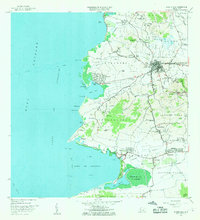 1966 Puerto Real1968 Print · USGSCabo Rojo and the southwestern coast of Puerto Rico come alive in the 1960s, showing a landscape of traditional haciendas and emerging coastal retreats. Researchers can trace the Ferrocarril del Oeste rail line or locate family landmarks like Hacienda La Ratina and Betances.3 unique versions available
 - 1966 Map of Cabo Rojo, 1968 Print
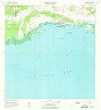
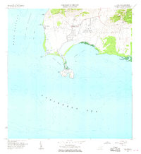 1966 Cabo Rojo1968 Print · USGSThe southwestern tip of Puerto Rico appears here in the mid-1960s, showing the intersection of coastal salt works and maritime navigation. Researchers can trace the local community at El Combate and locate the iconic Faro near Bahia Sucia.2 unique versions available
 - 1966 Map of San German, 1969 Print
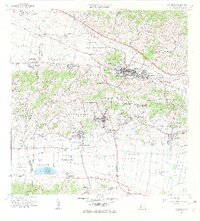 1966 San German1969 Print · USGSSan Germán and the surrounding Lajas Valley are captured here in the mid-sixties, showing a landscape defined by historic haciendas and rising urban centers. Genealogists and historians can trace family estates like Hacienda Resolución or locate local landmarks including the Cementerio de San Germán and Lajas Arriba.4 unique versions available
 - 1966 Map of Parguera, 1969 Print
 1966 Parguera1969 Print · USGSCoastal Lajas and Cabo Rojo are captured in the 1960s just as marine research and conservation were being formalized. Historians can trace the development of Parguera and locate regional landmarks like the NIH Research Facility or the Bahía Fosforescente shoreline.2 unique versions available
End of results
Showing maps 1-5 of 5
Frequently asked questions
- What are the different types of historical maps available for Cabo Rojo?
- What is the oldest map of Cabo Rojo?
- Where can I purchase historical maps of Cabo Rojo for my home or office?
- Where can I download high-res historical maps of Cabo Rojo?
- Are there historical topographic maps available for Cabo Rojo?
- Is there historical aerial imagery available for Cabo Rojo?
- Where are historical maps of Cabo Rojo sourced from?