Old Maps of Coral Bay, Saint Thomas - Saint John District for Genealogy
Trace your family roots with 3 historic maps of Coral Bay. These high-res maps reveal old neighborhoods, homesites, landmarks, and streets — helping you uncover where your ancestors lived and how the area evolved over time.
- Explore historic neighborhoods: Identify where your relatives may have lived in the 1800s or 1900s.
- Compare maps over time: Trace the changes in streets, buildings, and landmarks for multi-generational research.
- Perfect for genealogy & ancestry research: Used by family historians and researchers to map out lineage and migration.
These maps are an incredible resource for exploring your personal connection to Coral Bay's past.
Coral Bay, Saint Thomas - Saint John District maps
(3)- 1958 Map of Western St. John, 1959 Print
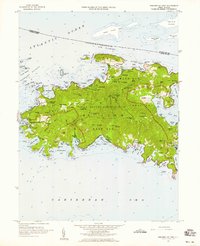 1958 Western St. John1959 Print · USGSSt. John in the late fifties shows a transition between traditional island life and the establishment of the Virgin Islands National Park. Genealogists and historians can trace family locations at Herman Farm, the settlement of Enighed, and the historic Emmaus church.6 unique versions available
 - 2013 Map of Coral Bay, 2013 Print
 2013 Coral Bay2013 Print · USGSCovers Coral Bay, including East End, Coral Harbour, and other nearby areas
 - 2024 Map of Coral Bay, 2024 Print
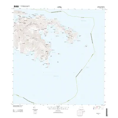
 2024 Coral Bay2024 Print · USGSSaint John’s eastern shores and the protected waters of Coral Bay are documented here in modern detail. Researchers can trace historic land tracts and heritage sites like the Annaberg Sugar Mill, Emmaus Moravian Church Cem, and Fortsberg.
End of results
Showing maps 1-3 of 3
Top cities near Coral Bay
Frequently asked questions
- What are the different types of historical maps available for Coral Bay?
- What is the oldest map of Coral Bay?
- Where can I purchase historical maps of Coral Bay for my home or office?
- Where can I download high-res historical maps of Coral Bay?
- Are there historical topographic maps available for Coral Bay?
- Is there historical aerial imagery available for Coral Bay?
- Where are historical maps of Coral Bay sourced from?