1970s Maps of Autauga County, Alabama
Explore 14 historic maps of Autauga County from the 1970s. These maps offer a rare glimpse into what life looked like during the 1970s — showing old roads, neighborhoods, homes, and landmarks that have changed or disappeared over time.
Whether you're researching your family's past, planning a metal detecting trip, or studying how Autauga County's landscape evolved across the 1970s, these high-resolution maps are a powerful tool for exploring the history of this region.
- Focus on a specific era: All maps on this page are from the 1970s, giving you a focused view of this time period.
- See what’s changed: Compare century-old streets, trails, and buildings to today's modern landscape using overlays and satellite layers.
- Research with precision: Use these maps for genealogy, historical research, land use analysis, or educational projects.
- View, download, or print: Maps are fully viewable online in high resolution, and can be downloaded or printed for your own records.
Start exploring Autauga County's history through authentic maps from the 1970s. This is your window into the past.
Autauga County, AL maps
(14)- 1975 Map of Benton SE
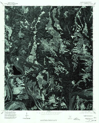
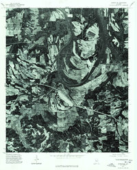 1975 Benton SE1975 Print · USGSBenton and the surrounding Lowndes County bottomlands are captured in detail during the mid-1970s. This aerial orthophotoquad allows researchers to see the actual fields and structures around the Benton settlement and the wide curves of the Alabama River.
 - 1975 Map of Autaugaville SW, 1977 Print
 1975 Autaugaville SW1977 Print · USGSLowndes County lands south of the Alabama River are shown in high-contrast aerial detail during the mid-seventies. Genealogists and land researchers can trace property lines and field patterns surrounding the settlement of White Hall.
 - 1975 Map of Autaugaville SE, 1977 Print
 1975 Autaugaville SE1977 Print · USGSLowndes County lands south of the Alabama River are shown in mid-seventies detail through this aerial study. Local historians can trace the development of Burkville and the era's evolving transportation and field patterns.
 - 1975 Map of Plantersville SE, 1977 Print
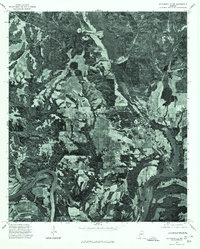
 1975 Plantersville SE1977 Print · USGSAutauga County's rural timber and farm lands are captured in the mid-1970s through this aerial photographic survey. Researchers can examine the exact landscape patterns surrounding Walkers Lake and trace the paths of countless unnamed country roads.
 - 1975 Map of Benton NE, 1977 Print
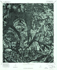
 1975 Benton NE1977 Print · USGSAutauga County's agricultural heartland and the winding Alabama River are captured in this mid-seventies aerial survey. Researchers can trace the rural landscape around Mulberry and study the intricate river meanders and historic property boundaries.
 - 1975 Map of Plantersville SW, 1977 Print
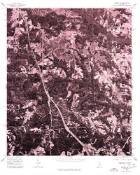
 1975 Plantersville SW1977 Print · USGSCovers Autauga County, including Valley Grande, Jones, and other nearby areas
 - 1975 Map of Montgomery NW, 1977 Print
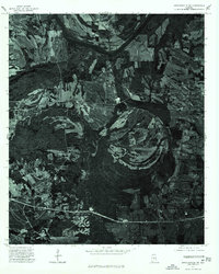
 1975 Montgomery NW1977 Print · USGSThe Alabama River corridor north of Montgomery shows a landscape of deep meanders and developing neighborhoods in the mid-seventies. Local historians can trace the intersection of rural land and new infrastructure along the banks of the Alabama River.
 - 1975 Map of Billingsley SE, 1977 Print
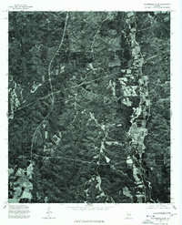
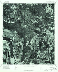
 1975 Billingsley SE1977 Print · USGSAutauga County's rural landscape is revealed in this mid-seventies aerial survey, showing the area's transition between forest and farm. Researchers can trace the layout of the settlement at Booth and follow the natural course of Bridge Creek.
 - 1975 Map of Autaugaville NW, 1977 Print
 1975 Autaugaville NW1977 Print · USGSAutauga County's riverfront landscape is revealed in this mid-seventies survey of the rural South. Trace the relationship between the bend of the Alabama River and the settlement at Autaugaville through detailed aerial imagery.
 - 1975 Map of Benton NW, 1977 Print
 1975 Benton NW1977 Print · USGSDallas County during the mid-1970s is seen through a detailed aerial lens, capturing the rural landscape between the city and surrounding settlements. Researchers can trace the development of Selma and locate the smaller hubs of Burnsville and Brantley.
 - 1975 Map of Autaugaville NE, 1977 Print
 1975 Autaugaville NE1977 Print · USGSAutauga County's riverfront and timberlands are captured in detail during the mid-seventies, showing the rural landscape of central Alabama. Genealogists and local historians can trace the roads and fields surrounding the settlement of Forester and the banks of the Alabama River.
 - 1975 Map of Montgomery SW, 1977 Print
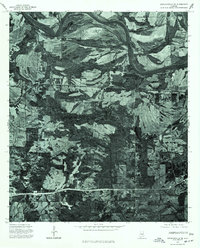
 1975 Montgomery SW1977 Print · USGSSouthwest of the state capital in the mid-seventies, this aerial view captures the rural-urban fringe as it transitioned from traditional farmland to modern infrastructure. Researchers can trace the winding course of the Alabama River and examine the intricate field patterns and roadways that defined the region at the time.
 - 1975 Map of Billingsley SW, 1977 Print
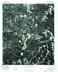
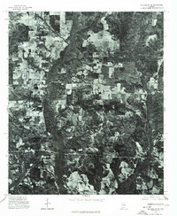
 1975 Billingsley SW1977 Print · USGSCentral Alabama's timber and farming lands come into focus in the mid-1970s. Researchers can trace the rural layouts of Independence and Vida to see how land was utilized at the height of the decade's rural development.
 - 1975 Map of Elmore SW, 1977 Print
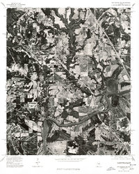
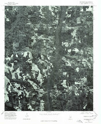
 1975 Elmore SW1977 Print · USGSCovers Autauga County, including Prattville, Millbrook, and other nearby areas
End of results
Showing maps 1-14 of 14
Top cities of Autauga County
- Prattville historical maps
- Pine Level historical maps
- Marbury historical maps
- Autaugaville historical maps
- Billingsley historical maps
Frequently asked questions
- What are the different types of historical maps available for Autauga County?
- What is the oldest map of Autauga County?
- Where can I purchase historical maps of Autauga County for my home or office?
- Where can I download high-res historical maps of Autauga County?
- Are there historical topographic maps available for Autauga County?
- Is there historical aerial imagery available for Autauga County?
- Where are historical maps of Autauga County sourced from?