1920s Maps of Fairhope, Alabama
Explore 2 historic maps of Fairhope from the 1920s. These maps offer a rare glimpse into what life looked like during the 1920s — showing old roads, neighborhoods, homes, and landmarks that have changed or disappeared over time.
Whether you're researching your family's past, planning a metal detecting trip, or studying how Fairhope's landscape evolved across the 1920s, these high-resolution maps are a powerful tool for exploring the history of this region.
- Focus on a specific era: All maps on this page are from the 1920s, giving you a focused view of this time period.
- See what’s changed: Compare century-old streets, trails, and buildings to today's modern landscape using overlays and satellite layers.
- Research with precision: Use these maps for genealogy, historical research, land use analysis, or educational projects.
- View, download, or print: Maps are fully viewable online in high resolution, and can be downloaded or printed for your own records.
Start exploring Fairhope's history through authentic maps from the 1920s. This is your window into the past.
Fairhope, AL maps
(2)- 1921 Map of Point Clear
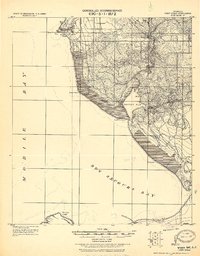 1921 Point Clear1921 Print · USGSThe eastern shore of Mobile Bay and its tidal inlets are captured here in the years following the Great War. Researchers can trace early coastal settlements like Point Clear, find family names at Seymours Bluff, and locate the historic Dixie Road corridor.2 unique versions available
 - 1921 Map of Fairhope
 1921 Fairhope1921 Print · USGSThe eastern shore of Mobile Bay comes alive in the early twentieth century as coastal colonies and timber towns expand. Trace the early streets of Fairhope and Daphne or follow the New Orleans Mobile and Pensacola R. R. through Loxley.
End of results
Showing maps 1-2 of 2
Top cities near Fairhope
- Mobile historical maps
- Daphne historical maps
- Foley historical maps
- Prichard historical maps
- Gulf Shores historical maps
- Spanish Fort historical maps
See more
Top neighborhoods of Fairhope
- Volanta historical maps
- Seacliff historical maps
- Magnolia Beach historical maps
- Montrose historical maps
Frequently asked questions
- What are the different types of historical maps available for Fairhope?
- What is the oldest map of Fairhope?
- Where can I purchase historical maps of Fairhope for my home or office?
- Where can I download high-res historical maps of Fairhope?
- Are there historical topographic maps available for Fairhope?
- Is there historical aerial imagery available for Fairhope?
- Where are historical maps of Fairhope sourced from?