1960s Maps of Blount County, Alabama
Explore 7 historic maps of Blount County from the 1960s. These maps offer a rare glimpse into what life looked like during the 1960s — showing old roads, neighborhoods, homes, and landmarks that have changed or disappeared over time.
Whether you're researching your family's past, planning a metal detecting trip, or studying how Blount County's landscape evolved across the 1960s, these high-resolution maps are a powerful tool for exploring the history of this region.
- Focus on a specific era: All maps on this page are from the 1960s, giving you a focused view of this time period.
- See what’s changed: Compare century-old streets, trails, and buildings to today's modern landscape using overlays and satellite layers.
- Research with precision: Use these maps for genealogy, historical research, land use analysis, or educational projects.
- View, download, or print: Maps are fully viewable online in high resolution, and can be downloaded or printed for your own records.
Start exploring Blount County's history through authentic maps from the 1960s. This is your window into the past.
Blount County, AL maps
(7)- 1960 Map of Gadsden
 1960 Gadsden1960 Print · USGSNorthern Alabama in the mid-1950s is defined by the mighty Tennessee River and its massive reservoirs. Trace the development of Huntsville and Redstone Arsenal or explore the vast William B Bankhead National Forest.2 unique versions available
 - 1960 Map of Remlap, 1963 Print
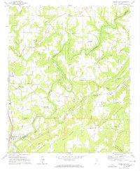
 1960 Remlap1963 Print · USGSCentral Alabama's ridges and valleys are meticulously detailed in the early 1960s, showing the intersection of rural life and early industrial expansion. Trace family history at Pleasant Mount Ch or explore the geography of Remlap and Inland Reservoir.6 unique versions available
 - 1961 Map of Nectar, 1963 Print
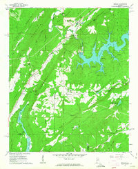
 1961 Nectar1963 Print · USGSBlount County communities thrived along the winding Locust Fork in the early sixties. Genealogists and historians can trace family-named sites like McAnally Cove, the Covered Bridge, and rural landmarks from Wallstown to Nectar.3 unique versions available
 - 1961 Map of Trafford, 1963 Print
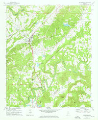
 1961 Trafford1963 Print · USGSThe rural coal and rail corridors north of Birmingham are frozen in time during the early sixties. Genealogists and local historians can trace family locations through numerous sites like Bradford (Dixiana PO), Sterling Sch, and the Masseyline Cem.5 unique versions available
 - 1963 Map of Gadsden
 1963 Gadsden1963 Print · USGSNorthern Alabama underwent a dramatic mid-century transformation as the Tennessee Valley became a hub for defense and industry. Researchers can trace the development of the Redstone Arsenal, the route of the Natchez Trace Parkway, and long-standing rail lines like the Southern Railway.
 - 1969 Map of Blountsville, 1972 Print
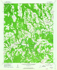
 1969 Blountsville1972 Print · USGSBlount County in the late sixties is documented here as a landscape of winding river bends and highland ridges. Researchers can locate several rural landmarks including Antioch Ch, Blackwood Bend on the Locust Fork, and the historic Huntsville Meridian passing through Blountsville.4 unique versions available
 - 1969 Map of Garden City, 1972 Print
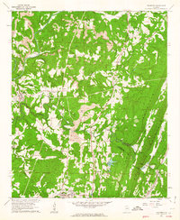
 1969 Garden City1972 Print · USGSCullman and Blount counties are shown here in the late sixties as the winding Mulberry Fork shaped local life. Researchers can trace rural lineages through numerous landmarks like Bethlehem East Ch, Chamblees Mill, and The Narrows.4 unique versions available
End of results
Showing maps 1-7 of 7
Top cities of Blount County
- Oneonta historical maps
- Blountsville historical maps
- Hayden historical maps
- Cleveland historical maps
- Locust Fork historical maps
- Snead historical maps
See more
Frequently asked questions
- What are the different types of historical maps available for Blount County?
- What is the oldest map of Blount County?
- Where can I purchase historical maps of Blount County for my home or office?
- Where can I download high-res historical maps of Blount County?
- Are there historical topographic maps available for Blount County?
- Is there historical aerial imagery available for Blount County?
- Where are historical maps of Blount County sourced from?