1970s Maps of Greenville, Alabama
Explore 3 historic maps of Greenville from the 1970s. These maps offer a rare glimpse into what life looked like during the 1970s — showing old roads, neighborhoods, homes, and landmarks that have changed or disappeared over time.
Whether you're researching your family's past, planning a metal detecting trip, or studying how Greenville's landscape evolved across the 1970s, these high-resolution maps are a powerful tool for exploring the history of this region.
- Focus on a specific era: All maps on this page are from the 1970s, giving you a focused view of this time period.
- See what’s changed: Compare century-old streets, trails, and buildings to today's modern landscape using overlays and satellite layers.
- Research with precision: Use these maps for genealogy, historical research, land use analysis, or educational projects.
- View, download, or print: Maps are fully viewable online in high resolution, and can be downloaded or printed for your own records.
Start exploring Greenville's history through authentic maps from the 1970s. This is your window into the past.
Greenville, AL maps
(3)- 1971 Map of Greenville West, 1973 Print
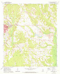
 1971 Greenville West1973 Print · USGSButler County in the early seventies shows the city of Greenville expanding westward into a landscape of rural churches and creek branches. Genealogists can trace family roots at Magnolia Cemetery or locate historic congregations like Pleasant Hill Ch and Giddens Ch.2 unique versions available
 - 1971 Map of Fort Dale, 1973 Print
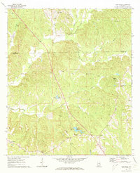 1971 Fort Dale1973 Print · USGSButler County's rural landscape is detailed here in the early seventies, showing a network of established homesteads and small communities. Genealogists and historians can trace family locations near Clover Hill, Manningham, or the site of Fort Dale.2 unique versions available
 - 1971 Map of Greenville East, 1973 Print
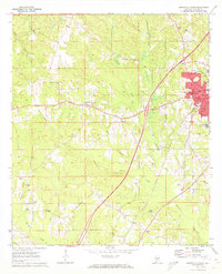
 1971 Greenville East1973 Print · USGSGreenville and the surrounding Butler County hills are captured here in the early seventies as the local economy balanced rail transit and surface mining. Genealogists can locate family landmarks like Pioneer Cem, Lomax-Hannon Jr College, and rural outposts such as Mashville.2 unique versions available
End of results
Showing maps 1-3 of 3
Top cities near Greenville
Top neighborhoods of Greenville
- South Street Historic District historical maps
- Commerce Street Residential Historic District historical maps
- East Commerce Street Historic District historical maps
- Post Office Historic District historical maps
- South Greenville Historic District historical maps
- Fort Dale-College Street Historic District historical maps
See more
Frequently asked questions
- What are the different types of historical maps available for Greenville?
- What is the oldest map of Greenville?
- Where can I purchase historical maps of Greenville for my home or office?
- Where can I download high-res historical maps of Greenville?
- Are there historical topographic maps available for Greenville?
- Is there historical aerial imagery available for Greenville?
- Where are historical maps of Greenville sourced from?