1940s Maps of Anniston, Alabama
Explore 6 historic maps of Anniston from the 1940s. These maps offer a rare glimpse into what life looked like during the 1940s — showing old roads, neighborhoods, homes, and landmarks that have changed or disappeared over time.
Whether you're researching your family's past, planning a metal detecting trip, or studying how Anniston's landscape evolved across the 1940s, these high-resolution maps are a powerful tool for exploring the history of this region.
- Focus on a specific era: All maps on this page are from the 1940s, giving you a focused view of this time period.
- See what’s changed: Compare century-old streets, trails, and buildings to today's modern landscape using overlays and satellite layers.
- Research with precision: Use these maps for genealogy, historical research, land use analysis, or educational projects.
- View, download, or print: Maps are fully viewable online in high resolution, and can be downloaded or printed for your own records.
Start exploring Anniston's history through authentic maps from the 1940s. This is your window into the past.
Anniston, AL maps
(6)- 1947 Map of Oxford, 1953 Print
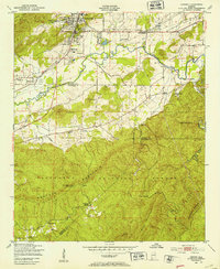 1947 Oxford1953 Print · USGSThe Choccolocco Creek valley in the late 1940s shows the growth of Oxford and Hobson City near the foothills. Researchers can trace local landmarks like Oxford Lake, Trinity Ch, and the old Southern railroad line.2 unique versions available
 - 1947 Map of Anniston, 1953 Print
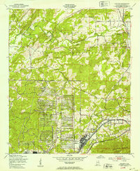
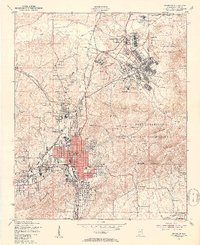 1947 Anniston1953 Print · USGSAnniston and the surrounding Calhoun County hills appear here in the immediate post-war period as the city and military grounds expanded. Researchers can trace the layout of the Fort Mc Clellan Military Reservation, locate the Prisoner of War Camp, and find local landmarks like Thankful Schools.2 unique versions available
 - 1947 Map of Jacksonville, 1953 Print
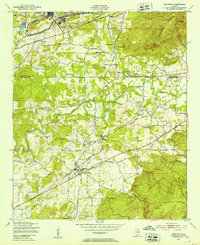
 1947 Jacksonville1953 Print · USGSPost-war Calhoun County comes alive through this mid-century survey of the Jacksonville area and its railway junctions. Genealogists can locate family landmarks like Munger Cem and Post Oak Springs Ch along the winding Tallahatchee Creek.
 - 1947 Map of Jacksonville, 1953 Print
 1947 Jacksonville1953 Print · USGSPostwar Etowah and Calhoun counties show a unique mix of expanding industrial centers and deeply rooted rural communities. Local historians can trace early school sites like Webster Sch and long-standing spiritual hubs such as Tredegar Chapel or Friendship Ch.
 - 1947 Map of Eulaton, 1953 Print
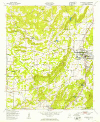
 1947 Eulaton1953 Print · USGSCalhoun County was a hub of military and rail activity in the years following World War II. Genealogists and historians can trace the intersection of small communities like Eulaton and Tarsus with the sprawling Anniston Ordnance Depot and New Bethel Cem.2 unique versions available
 - 1947 Map of Munford, 1953 Print
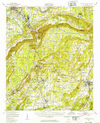
 1947 Munford1953 Print · USGSTalladega and Calhoun counties appear here in the late 1940s, showing a landscape defined by the intersection of military industrial sites and rural rail towns. Researchers can trace the old paths of the Louisville and Nashville railroad through Jenifer and locate schools like Sweet Home Sch.2 unique versions available
End of results
Showing maps 1-6 of 6
Top cities near Anniston
- Oxford historical maps
- Talladega historical maps
- Jacksonville historical maps
- Rainbow City historical maps
- Saks historical maps
- Southside historical maps
See more
Top neighborhoods of Anniston
- Pelham Heights historical maps
- Spring Valley historical maps
- Lardent historical maps
- Blue Mountain historical maps
- Golden Springs historical maps
- Lenlock historical maps
See more
Frequently asked questions
- What are the different types of historical maps available for Anniston?
- What is the oldest map of Anniston?
- Where can I purchase historical maps of Anniston for my home or office?
- Where can I download high-res historical maps of Anniston?
- Are there historical topographic maps available for Anniston?
- Is there historical aerial imagery available for Anniston?
- Where are historical maps of Anniston sourced from?