1900s (20th Century) Maps of Cherokee County, Alabama
Explore 40 historic maps of Cherokee County from the 1900s (20th Century). These maps offer a rare glimpse into what life looked like during the 1900s — showing old roads, neighborhoods, homes, and landmarks that have changed or disappeared over time.
Whether you're researching your family's past, planning a metal detecting trip, or studying how Cherokee County's landscape evolved across the 1900s, these high-resolution maps are a powerful tool for exploring the history of this region.
- Focus on a specific era: All maps on this page are from the 1900s, giving you a focused view of this time period.
- See what’s changed: Compare century-old streets, trails, and buildings to today's modern landscape using overlays and satellite layers.
- Research with precision: Use these maps for genealogy, historical research, land use analysis, or educational projects.
- View, download, or print: Maps are fully viewable online in high resolution, and can be downloaded or printed for your own records.
Start exploring Cherokee County's history through authentic maps from the 1900s. This is your window into the past.
Cherokee County, AL maps
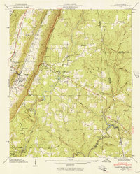
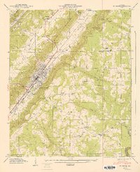
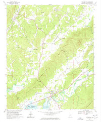
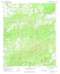
(40)- 1900 Map of Fort Payne
 1900 Fort Payne1900 Print · USGSNortheast Alabama is defined by its deep ridges and river valleys in the late nineteenth century. Researchers can trace the era's ferry network across the Coosa River and find old family-run landmarks like Wagners Store and Santy Mills.6 unique versions available
 - 1900 Map of Anniston
 1900 Anniston1900 Print · USGSNortheast Alabama thrived as a railroad and industrial crossroads at the turn of the century. Genealogists and researchers can trace family landmarks and early transport hubs from the Coosa River to Anniston, including Salt Creek Church and Fowler Ferry.6 unique versions available
 - 1904 Map of Rome
 1904 Rome1904 Print · USGSNorthwest Georgia and the Alabama borderlands are captured here during a period of heavy river traffic and expanding rail lines. Genealogists can trace family footprints across dozens of river crossings like Freeman Ferry and early settlements such as Chubbtown or Raccoon Mills.4 unique versions available
 - 1936 Map of Little Falls
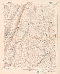
 1936 Little Falls1936 Print · USGSDeKalb County, Alabama, is captured in the mid-1930s just as the Tennessee Valley Authority began modernizing the region. Researchers can trace rural life through the upland community of Violet Hill, its Violet Hill Ch, and the high ridges of Lookout Mountain.
 - 1946 Map of Valley Head, 1956 Print
 1946 Valley Head1956 Print · USGSThe Alabama-Georgia state line and the slopes of Lookout Mountain are captured here in the mid-1940s. Genealogists and researchers can locate the Southern Railroad corridor, rural schools like Moon Lake Sch, and local landmarks including Mentone and Valley Head.2 unique versions available
 - 1946 Map of Portersville, 1958 Print
 1946 Portersville1958 Print · USGSDeKalb County and the southern reaches of Lookout Mountain appear here just after the war, showing a landscape defined by parallel ridges and valley rail lines. Genealogists can locate family landmarks like Longshore Mill, McNutt Memorial Ch, and the Brown Fell Sch.2 unique versions available
 - 1946 Map of Ft Payne, 1960 Print
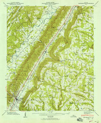
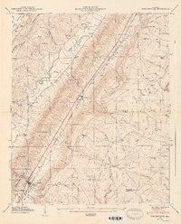
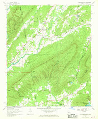
 1946 Ft Payne1960 Print · USGSDeKalb County’s rugged valley terrain is captured here just after the war, showing the industrial core of Fort Payne nestled beneath Lookout Mountain. Genealogists can trace family landmarks like Fisher Crossroads, Manitou Cave, and the Log Cabin Chapel.5 unique versions available
 - 1947 Map of Valley Head
 1947 Valley Head1947 Print · USGSDeKalb County and the Alabama-Georgia borderlands are captured here just after the war, showing the mountain communities and valley rail lines of the late 1940s. Genealogists can locate family landmarks like Jones Cem, Johns Chapel, and the Davenport Chapel School.2 unique versions available
 - 1947 Map of Ft Payne
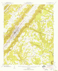
 1947 Ft Payne1947 Print · USGSThe valley city of Fort Payne and the surrounding ridges of DeKalb County appear in great detail during the late 1940s. Researchers can trace family history through sites like Fisher Sch, Manitou Cave, and the Glenwood Cem burial grounds.2 unique versions available
 - 1947 Map of Portersville
 1947 Portersville1947 Print · USGSBig Wills Valley was a vital rail and agricultural corridor after the war, tucked between the ridges of Sand and Lookout Mountains. Genealogists can trace family landmarks like Longshore Mill, the Brown Fell Sch, and country churches such as McNutt Memorial Ch.2 unique versions available
 - 1953 Map of Atlanta, 1965 Print
 1953 Atlanta1965 Print · USGSThe growing Atlanta metro and the industrial corridors of Eastern Alabama are captured here during the mid-century transition. Researchers can trace the rail-to-road shift through hubs like Anniston and La Grange or locate sites within Fort McClellan.2 unique versions available
 - 1955 Map of Rome
 1955 Rome1955 Print · USGSThe tri-state borderlands of Georgia, Alabama, and Tennessee appear in the mid-fifties as a landscape of ridge-and-valley industry and river navigation. Genealogists can trace family footprints near Chattanooga, the iron works of Gadsden, and textile towns like Trion or Summerville.
 - 1957 Map of Atlanta
 1957 Atlanta1957 Print · USGSAtlanta and the Alabama borderlands appear here in the mid-fifties, capturing the region's post-war suburban and industrial transition. Trace the development of early transport hubs and military sites like Fort McPherson, Anniston, and the Kennesaw Mountain National Battlefield Park.
 - 1958 Map of Atlanta
 1958 Atlanta1958 Print · USGSMid-century Georgia and Alabama are shown in this regional study of the corridor between the Chattahoochee River and the Appalachian foothills. Local historians can trace the development of suburban Atlanta alongside vital landmarks like Stone Mountain, Dobbins AFB, and the Seaboard Air Line rail routes.
 - 1958 Map of Rome, 1966 Print
 1958 Rome1966 Print · USGSNorthwest Georgia and neighboring Tennessee and Alabama are captured here in the late fifties, showcasing a landscape of high ridges and river valleys. Researchers can trace historic rail lines like the Seaboard Air Line RR and explore the bounds of Cloudland Canyon State Park or Fort Oglethorpe.3 unique versions available
 - 1961 Map of Rome
 1961 Rome1961 Print · USGSNorthwest Georgia and neighboring Tennessee and Alabama are shown here at a moment of significant mid-century growth. Researchers can trace the rail networks of the Central of Georgia or locate landmarks within Chickamauga and Chattanooga Nat Military Park.
 - 1963 Map of Rome
 1963 Rome1963 Print · USGSThe tri-state corner of Georgia, Alabama, and Tennessee is captured here during a period of massive reservoir expansion and post-war growth. Genealogists and historians can trace the rail corridors of the Southern Ry or locate landmarks like Fort Oglethorpe and Cloudland Canyon State Park.
 - 1966 Map of Borden Springs, 1967 Print
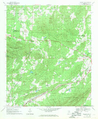
 1966 Borden Springs1967 Print · USGSSettlements along the Alabama-Georgia border were defined by the railroads and furnace industry in the 1960s. Genealogists and historians can locate family landmarks like Arrington Chapel Cem, the site of Tecumseh Furnace, and Borden Wheeler Springs.3 unique versions available
 - 1966 Map of Lyerly, 1969 Print
 1966 Lyerly1969 Print · USGSThe Chattooga River valley in the mid-sixties reveals a landscape of ridge-and-valley agriculture and small rail-side settlements. Genealogists and local historians can trace family locations near Lyerly, Menlo, and Alpine Ch, or locate the Summerville State Fish Hatchery and the Central of Georgia rail line.2 unique versions available
 - 1967 Map of Gaylesville
 1967 Gaylesville1967 Print · USGSGaylesville and the surrounding Chattooga River valley are captured here in the late sixties, showing a landscape of small settlements and mountain gaps. Genealogists can locate family landmarks like Randall Cem, Watson Chapel, and the Rinehart Jr High Sch.4 unique versions available
 - 1967 Map of Chattoogaville, 1968 Print
 1967 Chattoogaville1968 Print · USGSThe Georgia-Alabama state line and the Chattooga River valley are captured here in the late sixties as the region's rural character remained intact. Genealogists and local historians can trace family-named sites like Johnson Cem, visit Rock Hill Ch, or locate the old Fullerton School.
 - 1967 Map of Piedmont NW, 1969 Print
 1967 Piedmont NW1969 Print · USGSNortheast Alabama in the late sixties reveals a landscape of mountain ridges and rail-side settlements. Genealogists can trace family landmarks and rural life through Knightens Crossroads, Webb Sch, and the historic tracks of the Southern Railway.3 unique versions available
 - 1967 Map of Weisner Mountain, 1969 Print
 1967 Weisner Mountain1969 Print · USGSCherokee and Etowah counties are captured in the late sixties as the rural landscape transitions between the Coosa River and the high ridge of Weisner Mountain. Researchers can trace ancestral connections to family-named hubs like Plano and Ball Flat, or locate historic local landmarks such as Davis Chapel and Lake Weisner.2 unique versions available
 - 1967 Map of Indian Mountain, 1969 Print
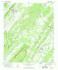
 1967 Indian Mountain1969 Print · USGSCherokee County, Alabama and Polk County, Georgia meet here in the late sixties along the slopes of the Appalachian foothills. Local historians can trace the foundations of the area through family-named landmarks and old communities like Forney, Bluffton, and Etna.3 unique versions available
 - 1967 Map of Cedar Bluff, 1969 Print
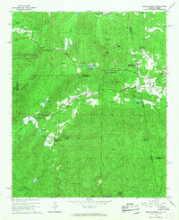
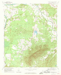
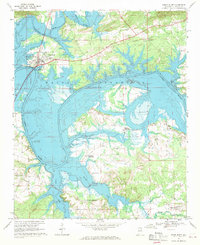 1967 Cedar Bluff1969 Print · USGSCherokee County, Alabama, is documented here in the late sixties as the newly created Weiss Reservoir reshaped the valley. Trace rural family roots at several historic intersections like Newberry Crossroads, Howells Crossroads, and St Marks Ch.3 unique versions available
Showing maps 1-25 of 40
Top cities of Cherokee County
- Centre historical maps
- Cedar Bluff historical maps
- Leesburg historical maps
- Sand Rock historical maps
- Spring Garden historical maps
- Gaylesville historical maps
Frequently asked questions
- What are the different types of historical maps available for Cherokee County?
- What is the oldest map of Cherokee County?
- Where can I purchase historical maps of Cherokee County for my home or office?
- Where can I download high-res historical maps of Cherokee County?
- Are there historical topographic maps available for Cherokee County?
- Is there historical aerial imagery available for Cherokee County?
- Where are historical maps of Cherokee County sourced from?