1970s Maps of Cherokee County, Alabama
Explore 3 historic maps of Cherokee County from the 1970s. These maps offer a rare glimpse into what life looked like during the 1970s — showing old roads, neighborhoods, homes, and landmarks that have changed or disappeared over time.
Whether you're researching your family's past, planning a metal detecting trip, or studying how Cherokee County's landscape evolved across the 1970s, these high-resolution maps are a powerful tool for exploring the history of this region.
- Focus on a specific era: All maps on this page are from the 1970s, giving you a focused view of this time period.
- See what’s changed: Compare century-old streets, trails, and buildings to today's modern landscape using overlays and satellite layers.
- Research with precision: Use these maps for genealogy, historical research, land use analysis, or educational projects.
- View, download, or print: Maps are fully viewable online in high resolution, and can be downloaded or printed for your own records.
Start exploring Cherokee County's history through authentic maps from the 1970s. This is your window into the past.
Cherokee County, AL maps
(3)- 1975 Map of Borden Springs, 1977 Print
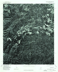 1975 Borden Springs1977 Print · USGSThe Alabama and Georgia borderlands are captured in clear aerial detail during the mid-1970s. Local history enthusiasts can trace the exact buildings and road networks surrounding Borden Springs and the border settlement of Esom Hill.
 - 1975 Map of Piedmont, 1977 Print
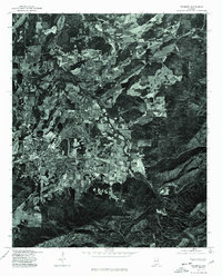 1975 Piedmont1977 Print · USGSPiedmont and the surrounding Alabama countryside are shown in this mid-seventies photographic study. Genealogists and local historians can trace property boundaries and land use patterns along the banks of Terrapin Creek.
 - 1975 Map of Portersville, 1977 Print
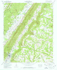 1975 Portersville1977 Print · USGSDeKalb County and the parallel ridges of the Alabama valley-and-ridge country are captured here in the mid-seventies. Genealogists and local historians can trace family burial sites like Warren-Stewart Cem and Plunket Cem or explore the early infrastructure of Collinsville.2 unique versions available
End of results
Showing maps 1-3 of 3
Top cities of Cherokee County
- Centre historical maps
- Cedar Bluff historical maps
- Leesburg historical maps
- Sand Rock historical maps
- Spring Garden historical maps
- Gaylesville historical maps
Frequently asked questions
- What are the different types of historical maps available for Cherokee County?
- What is the oldest map of Cherokee County?
- Where can I purchase historical maps of Cherokee County for my home or office?
- Where can I download high-res historical maps of Cherokee County?
- Are there historical topographic maps available for Cherokee County?
- Is there historical aerial imagery available for Cherokee County?
- Where are historical maps of Cherokee County sourced from?