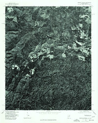
1975 Map of Borden Springs
USGS Topo · Published 1977About this map
Borden Springs and the surrounding woodlands of Cleburne County appear in high-contrast detail in this 1975 orthophotoquad. This specialized map format uses rectified aerial photography to provide a literal view of the landscape, revealing the exact footprints of structures, the dense patterns of forest canopy, and the winding path of rural roads. To the east, the settlement of Esom Hill sits near the Georgia border, where the clearing of land for agriculture creates a stark visual contrast with the heavily timbered hillsides that dominate the region. Because this is an orthophotograph rather than a traditional line map, researchers can observe the precise layout of local farmsteads and the specific density of the vegetation along the Alabama and Georgia line during the mid-1970s.
Find a feature on this map
2 named features on this map. Tap any name to fly to it.
Don’t see what you’re looking for? This feature index may not catch every label — zoom into the map to look around manually.
Map Details
Editions of this 1975 Borden Springs Map
This is the sole edition of this map. No revisions or reprints were ever made.
Other maps of this area

1886 · Rome
USGS Topo · 1:125,000

1889 · Tallapoosa
USGS Topo · 1:125,000

1892 · Tallapoosa
USGS Topo · 1:125,000

1893 · Fort Payne
USGS Topo · 1:125,000

1897 · Tallapoosa
USGS Topo · 1:125,000

1898 · Rome
USGS Topo · 1:125,000

1898 · Fort Payne
USGS Topo · 1:125,000

1899 · Rome
USGS Topo · 1:125,000

1900 · Fort Payne
USGS Topo · 1:125,000

1900 · Anniston
USGS Topo · 1:125,000