1970s Maps of Silas, Alabama
Explore 2 historic maps of Silas from the 1970s. These maps offer a rare glimpse into what life looked like during the 1970s — showing old roads, neighborhoods, homes, and landmarks that have changed or disappeared over time.
Whether you're researching your family's past, planning a metal detecting trip, or studying how Silas's landscape evolved across the 1970s, these high-resolution maps are a powerful tool for exploring the history of this region.
- Focus on a specific era: All maps on this page are from the 1970s, giving you a focused view of this time period.
- See what’s changed: Compare century-old streets, trails, and buildings to today's modern landscape using overlays and satellite layers.
- Research with precision: Use these maps for genealogy, historical research, land use analysis, or educational projects.
- View, download, or print: Maps are fully viewable online in high resolution, and can be downloaded or printed for your own records.
Start exploring Silas's history through authentic maps from the 1970s. This is your window into the past.
Silas, AL maps
(2)- 1974 Map of Millry North, 1977 Print
 1974 Millry North1977 Print · USGSThe border of Washington and Choctaw Counties is captured here in the mid-1970s, as the St Louis-San Francisco railroad connects rural hubs. Trace family roots at Winsletts Cem or Mt Zion Chapel, and locate the historic Healing Springs.
 - 1974 Map of Silas, 1977 Print
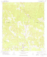
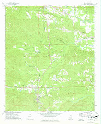 1974 Silas1977 Print · USGSIn the mid-1970s, this area of Choctaw County was a hub of timber, oil extraction, and deep-rooted rural communities. Genealogists can trace family footprints through numerous local landmarks, including the Harrison Cem, Shady Grove Sch, and the St Louis-San Francisco rail line.2 unique versions available
End of results
Showing maps 1-2 of 2
Top cities near Silas
Top neighborhoods of Silas
Frequently asked questions
- What are the different types of historical maps available for Silas?
- What is the oldest map of Silas?
- Where can I purchase historical maps of Silas for my home or office?
- Where can I download high-res historical maps of Silas?
- Are there historical topographic maps available for Silas?
- Is there historical aerial imagery available for Silas?
- Where are historical maps of Silas sourced from?