1980s Maps of Cleburne County, Alabama
Explore 2 historic maps of Cleburne County from the 1980s. These maps offer a rare glimpse into what life looked like during the 1980s — showing old roads, neighborhoods, homes, and landmarks that have changed or disappeared over time.
Whether you're researching your family's past, planning a metal detecting trip, or studying how Cleburne County's landscape evolved across the 1980s, these high-resolution maps are a powerful tool for exploring the history of this region.
- Focus on a specific era: All maps on this page are from the 1980s, giving you a focused view of this time period.
- See what’s changed: Compare century-old streets, trails, and buildings to today's modern landscape using overlays and satellite layers.
- Research with precision: Use these maps for genealogy, historical research, land use analysis, or educational projects.
- View, download, or print: Maps are fully viewable online in high resolution, and can be downloaded or printed for your own records.
Start exploring Cleburne County's history through authentic maps from the 1980s. This is your window into the past.
Cleburne County, AL maps
(2)- 1981 Map of Anniston, 1982 Print
 1981 Anniston1982 Print · USGSNortheast Alabama and the Georgia borderlands come alive in the early eighties, showing a landscape of heavy industry, military outposts, and mountain forests. Genealogists and historians can trace the development of towns like Anniston and Carrollton, or locate landmarks such as Whitesides Mill and Webster Chapel.2 unique versions available
 - 1983 Map of Ironaton, 1985 Print
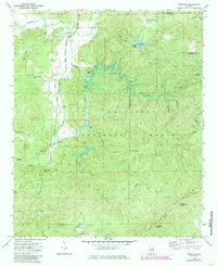 1983 Ironaton1985 Print · USGSTalladega County at the start of the eighties shows a landscape shaped by both forest conservation and industry. Genealogists can locate rural landmarks like Smith Chapel, Ironaton, and the McElderry Grave site along the abandoned rail line.
End of results
Showing maps 1-2 of 2
Top cities of Cleburne County
- Heflin historical maps
- Hollis Crossroads historical maps
- Ranburne historical maps
- Fruithurst historical maps
- Edwardsville historical maps
Frequently asked questions
- What are the different types of historical maps available for Cleburne County?
- What is the oldest map of Cleburne County?
- Where can I purchase historical maps of Cleburne County for my home or office?
- Where can I download high-res historical maps of Cleburne County?
- Are there historical topographic maps available for Cleburne County?
- Is there historical aerial imagery available for Cleburne County?
- Where are historical maps of Cleburne County sourced from?