1980s Maps of Crenshaw County, Alabama
Explore 5 historic maps of Crenshaw County from the 1980s. These maps offer a rare glimpse into what life looked like during the 1980s — showing old roads, neighborhoods, homes, and landmarks that have changed or disappeared over time.
Whether you're researching your family's past, planning a metal detecting trip, or studying how Crenshaw County's landscape evolved across the 1980s, these high-resolution maps are a powerful tool for exploring the history of this region.
- Focus on a specific era: All maps on this page are from the 1980s, giving you a focused view of this time period.
- See what’s changed: Compare century-old streets, trails, and buildings to today's modern landscape using overlays and satellite layers.
- Research with precision: Use these maps for genealogy, historical research, land use analysis, or educational projects.
- View, download, or print: Maps are fully viewable online in high resolution, and can be downloaded or printed for your own records.
Start exploring Crenshaw County's history through authentic maps from the 1980s. This is your window into the past.
Crenshaw County, AL maps
(5)- 1981 Map of Sellers
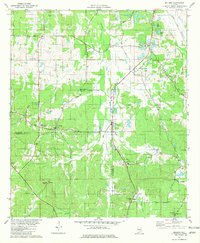 1981 Sellers1981 Print · USGSCentral Alabama's agricultural heartland is documented here in the early eighties, showing the transition between Montgomery and Crenshaw Counties. Researchers can locate family landmarks like Bell Cem, rural churches such as Fair Prospect Ch, and trace the path of the Seaboard Coast Line railroad.2 unique versions available
 - 1981 Map of Sandy Ridge, 1982 Print
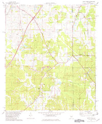 1981 Sandy Ridge1982 Print · USGSLowndes County and its neighbors are captured here in the early eighties as a rural landscape of family cemeteries and crossroad hamlets. Researchers can find generational landmarks like Lily Ch Cem, Sawyer Cem, and the settlement of Guys Village.2 unique versions available
 - 1986 Map of Montgomery
 1986 Montgomery1986 Print · USGSCentral Alabama's river-and-rail corridor is captured in the mid-1980s, centered on the state capital and its surrounding rural counties. Researchers can trace ancestral landmarks like Oakwood Cemetery, military sites like Maxwell Air Force Base, and small towns such as Lowndesboro.2 unique versions available
 - 1986 Map of Andalusia
 1986 Andalusia1986 Print · USGSCovington County and the Wiregrass region are shown here in the mid-1980s, centered on the growing hubs of Andalusia and Opp. Genealogists and local historians can trace legacy sites like the Old Pioneer Cem, Straughn Sch, and the rail lines of the Louisville and Nashville RR.2 unique versions available
 - 1986 Map of Greenville
 1986 Greenville1986 Print · USGSMid-century South Central Alabama comes alive in this survey of the creek-laced timberlands and rail-dependent towns between the Gulf Coastal Plain and the Piedmont. Researchers can trace family roots through numerous country landmarks like Magnolia Cem, Spring Hill Ch, and the Butler County State Wildlife Management Area.2 unique versions available
End of results
Showing maps 1-5 of 5
Top cities of Crenshaw County
- Luverne historical maps
- Brantley historical maps
- Rutledge historical maps
- Dozier historical maps
- Glenwood historical maps
- Petrey historical maps
Frequently asked questions
- What are the different types of historical maps available for Crenshaw County?
- What is the oldest map of Crenshaw County?
- Where can I purchase historical maps of Crenshaw County for my home or office?
- Where can I download high-res historical maps of Crenshaw County?
- Are there historical topographic maps available for Crenshaw County?
- Is there historical aerial imagery available for Crenshaw County?
- Where are historical maps of Crenshaw County sourced from?