1960s Maps of Crenshaw County, Alabama
Explore 5 historic maps of Crenshaw County from the 1960s. These maps offer a rare glimpse into what life looked like during the 1960s — showing old roads, neighborhoods, homes, and landmarks that have changed or disappeared over time.
Whether you're researching your family's past, planning a metal detecting trip, or studying how Crenshaw County's landscape evolved across the 1960s, these high-resolution maps are a powerful tool for exploring the history of this region.
- Focus on a specific era: All maps on this page are from the 1960s, giving you a focused view of this time period.
- See what’s changed: Compare century-old streets, trails, and buildings to today's modern landscape using overlays and satellite layers.
- Research with precision: Use these maps for genealogy, historical research, land use analysis, or educational projects.
- View, download, or print: Maps are fully viewable online in high resolution, and can be downloaded or printed for your own records.
Start exploring Crenshaw County's history through authentic maps from the 1960s. This is your window into the past.
Crenshaw County, AL maps
(5)- 1968 Map of Danleys Crossroads, 1970 Print
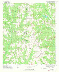 1968 Danleys Crossroads1970 Print · USGSSoutheast Alabama in the late sixties reveals a landscape of tight-knit farming communities at the junction of Coffee, Crenshaw, and Covington Counties. Researchers can trace family history through local landmarks like Mt Olive Ch, Danleys Crossroads, and Friendship.2 unique versions available
 - 1968 Map of Glenwood, 1970 Print
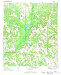
 1968 Glenwood1970 Print · USGSCrenshaw and Pike counties appear here in the late sixties as a landscape of river-bottom farms and emerging strip mines. Genealogists can trace family names at Emmaus Cem and Shirleys Crossroads or follow the Georgia Central Railroad through Glenwood.2 unique versions available
 - 1968 Map of Bullock, 1971 Print
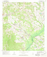
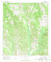
 1968 Bullock1971 Print · USGSCrenshaw County is documented here in the late sixties as the timber and rail economy shaped the rural landscape. Genealogists and local historians can locate many rural landmarks including Mt Zion Ch, Oak Grove Cem, and the Central of Georgia line.
 - 1968 Map of Petrey, 1971 Print
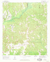
 1968 Petrey1971 Print · USGSSoutheast Alabama is captured here in the late sixties, showing the rural communities along the Crenshaw and Pike County line. Genealogists and historians can trace the Old Railroad Grade and locate ancestral sites like Petrey Cemetery and Camp Ground Church.
 - 1968 Map of Grady, 1971 Print
 1968 Grady1971 Print · USGSAgricultural life in the late sixties centers on the intersection of three counties and the SEABOARD COAST LINE railroad. Genealogists can trace family landmarks like Carter Cem, Shady Grove, and Rockelyn Ch along the Patsaliga Creek drainage.2 unique versions available
End of results
Showing maps 1-5 of 5
Top cities of Crenshaw County
- Luverne historical maps
- Brantley historical maps
- Rutledge historical maps
- Dozier historical maps
- Glenwood historical maps
- Petrey historical maps
Frequently asked questions
- What are the different types of historical maps available for Crenshaw County?
- What is the oldest map of Crenshaw County?
- Where can I purchase historical maps of Crenshaw County for my home or office?
- Where can I download high-res historical maps of Crenshaw County?
- Are there historical topographic maps available for Crenshaw County?
- Is there historical aerial imagery available for Crenshaw County?
- Where are historical maps of Crenshaw County sourced from?