1970s Maps of Luverne, Alabama
Explore 2 historic maps of Luverne from the 1970s. These maps offer a rare glimpse into what life looked like during the 1970s — showing old roads, neighborhoods, homes, and landmarks that have changed or disappeared over time.
Whether you're researching your family's past, planning a metal detecting trip, or studying how Luverne's landscape evolved across the 1970s, these high-resolution maps are a powerful tool for exploring the history of this region.
- Focus on a specific era: All maps on this page are from the 1970s, giving you a focused view of this time period.
- See what’s changed: Compare century-old streets, trails, and buildings to today's modern landscape using overlays and satellite layers.
- Research with precision: Use these maps for genealogy, historical research, land use analysis, or educational projects.
- View, download, or print: Maps are fully viewable online in high resolution, and can be downloaded or printed for your own records.
Start exploring Luverne's history through authentic maps from the 1970s. This is your window into the past.
Luverne, AL maps
(2)- 1971 Map of Luverne, 1973 Print
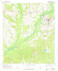 1971 Luverne1973 Print · USGSLuverne and the surrounding Crenshaw County countryside are captured here in the early seventies, centered on the Patsaliga Creek basin. Researchers can trace local lineage at Faith Hill Ch, Antioch Cem, and the rural Ivy Creek Sch.
 - 1971 Map of Fullers Crossroads, 1973 Print
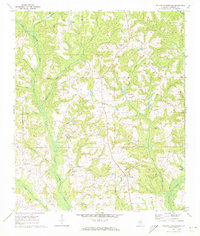 1971 Fullers Crossroads1973 Print · USGSCrenshaw County is documented here in the early seventies, showing a landscape of rural crossroads and creekside settlements. Genealogists can locate family landmarks like Mitchell Cem, Rock Hill Ch, and the community at Fullers Crossroads.
End of results
Showing maps 1-2 of 2
Top cities near Luverne
- Brantley historical maps
- Rutledge historical maps
- Dozier historical maps
- Goshen historical maps
- Glenwood historical maps
- Petrey historical maps
Frequently asked questions
- What are the different types of historical maps available for Luverne?
- What is the oldest map of Luverne?
- Where can I purchase historical maps of Luverne for my home or office?
- Where can I download high-res historical maps of Luverne?
- Are there historical topographic maps available for Luverne?
- Is there historical aerial imagery available for Luverne?
- Where are historical maps of Luverne sourced from?