1980s Maps of Wetumpka, Alabama
Explore 6 historic maps of Wetumpka from the 1980s. These maps offer a rare glimpse into what life looked like during the 1980s — showing old roads, neighborhoods, homes, and landmarks that have changed or disappeared over time.
Whether you're researching your family's past, planning a metal detecting trip, or studying how Wetumpka's landscape evolved across the 1980s, these high-resolution maps are a powerful tool for exploring the history of this region.
- Focus on a specific era: All maps on this page are from the 1980s, giving you a focused view of this time period.
- See what’s changed: Compare century-old streets, trails, and buildings to today's modern landscape using overlays and satellite layers.
- Research with precision: Use these maps for genealogy, historical research, land use analysis, or educational projects.
- View, download, or print: Maps are fully viewable online in high resolution, and can be downloaded or printed for your own records.
Start exploring Wetumpka's history through authentic maps from the 1980s. This is your window into the past.
Wetumpka, AL maps
(6)- 1986 Map of Montgomery
 1986 Montgomery1986 Print · USGSCentral Alabama's river-and-rail corridor is captured in the mid-1980s, centered on the state capital and its surrounding rural counties. Researchers can trace ancestral landmarks like Oakwood Cemetery, military sites like Maxwell Air Force Base, and small towns such as Lowndesboro.2 unique versions available
 - 1986 Map of Clanton
 1986 Clanton1986 Print · USGSCentral Alabama’s river-driven landscape is captured here in the mid-eighties, centered on the growth of Clanton and the hydroelectric lakes of the Coosa River. Genealogists and historians can trace the Old Indian Treaty Boundary or locate landmarks like Sykes Mill and Collins Chapel.
 - 1987 Map of Elmore
 1987 Elmore1987 Print · USGSThe riverfront communities of Elmore County appear in the late 1980s as the Coosa River landscape transitions from industrial dam sites to historic parklands. Researchers can trace family roots at Jones Chapel, Zeigler Cem, and the old settlement of Coosada.2 unique versions available
 - 1987 Map of Willow Springs
 1987 Willow Springs1987 Print · USGSGreater Montgomery and the Elmore County line come alive in this late 1980s survey of the riverbend country. Genealogists and local historians can trace family markers at Young Cem and Peck Cem or locate the sprawling Gunter AF Station.2 unique versions available
 - 1987 Map of Wetumpka
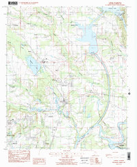
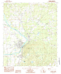 1987 Wetumpka1987 Print · USGSWetumpka and the surrounding Elmore County landscape are captured here in the late twentieth century as the town expanded along the COOSA RIVER. Local historians can trace established community sites like Wallsboro, the Julia Tutwiler Prison, and family landmarks such as Harwell Cem.2 unique versions available
 - 1987 Map of Clanton, 1990 Print
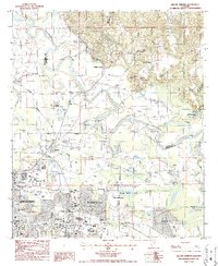
 1987 Clanton1990 Print · USGSCentral Alabama in the late eighties reveals a landscape of massive river reservoirs and forest reserves. Trace the rail-and-road corridors through Clanton and Wetumpka to find historic sites like Fort Toulouse and Collins Chapel.
End of results
Showing maps 1-6 of 6
Top cities near Wetumpka
- Montgomery historical maps
- Prattville historical maps
- Millbrook historical maps
- Pike Road historical maps
- Holtville historical maps
- Emerald Mountain historical maps
See more
Top neighborhoods of Wetumpka
- Willow Springs historical maps
- Wallsboro historical maps
- Blueberry Hill historical maps
- Harrogate Springs historical maps
- Tarwater historical maps
Frequently asked questions
- What are the different types of historical maps available for Wetumpka?
- What is the oldest map of Wetumpka?
- Where can I purchase historical maps of Wetumpka for my home or office?
- Where can I download high-res historical maps of Wetumpka?
- Are there historical topographic maps available for Wetumpka?
- Is there historical aerial imagery available for Wetumpka?
- Where are historical maps of Wetumpka sourced from?