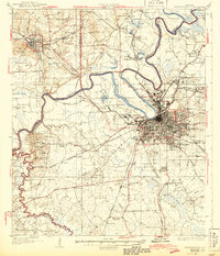
1986 Map of Montgomery
USGS Topo · Published 1986About this map
The confluence of the Alabama River, Coosa River, and Tallapoosa River anchors this regional study, centered on the urban growth of Montgomery during the mid-1980s. The city's footprint is defined by major military and educational installations, including Maxwell Air Force Base, Gunter Air Force Sta, and the campus of Auburn Univ (Montgomery). Beyond the capital, the landscape transitions into the agricultural reaches of Autauga, Lowndes, and Dallas counties, where small settlements like Lowndesboro and Hayneville maintain their distinct rural identities.
Find a feature on this map
156 named features on this map. Tap any name to fly to it.
Don’t see what you’re looking for? This feature index may not catch every label — zoom into the map to look around manually.
Map Details
Editions of this 1986 Montgomery Map
2 editions found
Historical Maps of Montgomery Through Time
7 maps found