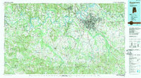
1986 Map of Montgomery
USGS Topo · Published 1989About this map
Montgomery sits at the heart of this mid-1980s landscape, serving as a hub where the Alabama River and Tallapoosa River converge. The urban center is defined by major transportation corridors, including Interstate 65 and the Western Railway of Alabama, alongside prominent military installations like Maxwell Air Force Base and Gunter Air Force Base. Moving west toward Selma, the map transitions into the fertile Black Belt region, characterized by extensive creek networks like Catoma Creek and Pintlala Creek. Small agricultural communities and junctions such as Lowndesboro, Autaugaville, and Hayneville anchor the surrounding counties. This survey illustrates the relationship between the state capital and its rural hinterlands, showing the reach of regional institutions like Auburn Univ (Montgomery) and local landmarks including Dannelly Field and the Oakwood Cemetery.
Find a feature on this map
142 named features on this map. Tap any name to fly to it.
Don’t see what you’re looking for? This feature index may not catch every label — zoom into the map to look around manually.
Map Details
Editions of this 1986 Montgomery Map
2 editions found
Other maps of this area

1891 · Clanton
USGS Topo · 1:125,000

1901 · Wetumpka
USGS Topo · 1:125,000

1901 · Wetumpka
USGS Topo · 1:62,500

1903 · Wetumpka
USGS Topo · 1:125,000

1906 · Dadeville
USGS Topo · 1:125,000

1927 · Montgomery
USGS Topo · 1:48,000

1930 · Montgomery
USGS Topo · 1:62,500

1953 · Montgomery
USGS Topo · 1:250,000

1953 · Andalusia
USGS Topo · 1:250,000

1953 · Dothan
USGS Topo · 1:250,000